The Pacific Ocean is the largest of the oceans. Its area is 178.7 million km 2. The ocean surpasses in area all the continents combined, and has a rounded configuration: it is noticeably elongated from the northwest to the southeast, therefore air and water masses reach the greatest development here in the vast northwestern and southeastern water areas. The length of the ocean from north to south is about 16 thousand km, from west to east - more than 19 thousand km. It reaches its maximum width in the equatorial-tropical latitudes, so it is the warmest of the oceans. The volume of water is 710.4 million km 3 (53% of the water volume of the World Ocean). The average depth of the ocean is 3980 m, the maximum is 11,022 m (Marian Trench).
The ocean washes with its waters the shores of almost all continents except Africa. It reaches Antarctica on a broad front, and its cooling influence extends through the waters far to the north. On the contrary, Quiet is protected from cold air masses by considerable isolation (the close location of Chukotka and Alaska with a narrow strait between them). In this regard, the northern half of the ocean is warmer than the southern. Pool Pacific Ocean connected to all other oceans. The boundaries between them are rather arbitrary. The most reasonable border with the Arctic Ocean: it runs along the underwater rapids of the narrow (86 km) Bering Strait somewhat south of the Arctic Circle. The border with the Atlantic Ocean runs along the wide Drake Passage (along the line Cape Horn in the archipelago - Cape Sternek on the Antarctic Peninsula). The border with the Indian Ocean is conditional.
Usually it is carried out as follows: the Malay Archipelago is assigned to the Pacific Ocean, and between Australia and Antarctica the oceans delimit along the meridian of the South Cape (Tasmania Island, 147 ° E). The official boundary with the Southern Ocean ranges from 36° S. sh. off the coast of South America to 48 ° S. sh. (at 175°W). The outlines of the coastline are rather simple on the eastern margin of the ocean and very complex on the western margin, where the ocean occupies a complex of marginal and interisland seas, island arcs, and deep-water trenches. This is a vast region of the largest horizontal and vertical dissection of the earth's crust on Earth. The marginal type includes seas off the coast of Eurasia and Australia. Most of the inter-island seas are located in the area of the Malay Archipelago. They are often combined under the general name of the Australo-Asiatic. The seas are separated from the open ocean by numerous groups of islands and peninsulas. Island arcs are usually accompanied by deep-sea trenches, the number and depth of which is unparalleled in the Pacific Ocean. The coasts of North and South America are slightly indented, there are no marginal seas and such large clusters of islands. Deep-sea trenches are located directly off the coasts of the continents. Off the coast of Antarctica in the Pacific sector there are three large marginal seas: Ross, Amundsen and Bellingshausen.
The margins of the ocean, together with the adjacent parts of the continents, are included in the Pacific mobile belt ("ring of fire"), which is characterized by powerful manifestations of modern volcanism and seismic activity.
The islands of the central and southwestern parts of the ocean are united under the general name Oceania.
Its unique records are associated with the huge size of the Pacific Ocean: it is the deepest, warmest on the surface, the highest wind waves are formed here, the most destructive tropical hurricanes and tsunamis, etc. The position of the ocean in all latitudes determines its exceptional diversity. natural conditions and resources.
Occupying about 1/3 of the surface of our planet and almost 1/2 of the area, the Pacific Ocean is not only a unique geophysical object of the Earth, but also largest region multilateral economic activity and diverse interests of mankind. Since ancient times, the inhabitants of the Pacific shores and islands have mastered biological resources coastal waters and made short voyages. Over time, other resources began to be involved in the economy, their use gained a wide industrial scope. Today, the Pacific Ocean plays a very important role in the life of many countries and peoples, which is largely determined by its natural conditions, economic and political factors.
Features of the economic and geographical position of the Pacific Ocean
In the north, vast expanses of the Pacific Ocean through the Bering Strait are connected to the Arctic Ocean.
The border between them runs along a conditional line: Cape Unikyn (Chukotka Peninsula) - Shishmareva Bay (Seward Peninsula). In the west, the Pacific Ocean is bounded by the Asian mainland, in the southwest by the shores of the islands of Sumatra, Java, Timor, then by the east coast of Australia and a conditional line crossing the Bass Strait and then following along the coast of Tasmania, and to the south along the ridge of underwater rises to Cape Alden on Wilkes Land in . The eastern limits of the ocean are the shores of North and South America, and to the south - a conditional line from the island of Tierra del Fuego to the Antarctic Peninsula on the mainland of the same name. In the extreme South, the waters of the Pacific Ocean wash Antarctica. Within these limits, it occupies an area of 179.7 million km2, including marginal seas.
The ocean has a spherical shape, especially pronounced in the northern and eastern parts. Its greatest extent in latitude (about 10,500 miles) is noted along the parallel of 10°N, and the greatest length (about 8,500 miles) falls on the meridian of 170°W. Such great distances between the northern and southern, western and eastern shores are an essential natural feature of this ocean.
The coastline of the ocean is strongly indented in the west, in the east the coasts are mountainous and poorly dissected. In the north, west and south of the ocean there are large seas: Bering, Okhotsk, Japan, Yellow, East China, South China, Sulawesi, Yavan, Ross, Amundsen, Bellingshausen, etc.
The bottom relief of the Pacific Ocean is complex and uneven. In most of the transition zone, the shelves do not have significant development. For example, off the American coast, the width of the shelf does not exceed several tens of kilometers, but in the Bering, East China, and South China seas it reaches 700-800 km. In general, the shelves occupy about 17% of the entire transition zone. Continental slopes are steep, often stepped, dissected by submarine canyons. The ocean bed occupies a huge space. By a system of large uplifts, ridges and individual mountains, wide and relatively low swells, it is divided into large basins: Northeast, Northwest, East Mariana, West Caroline, Central, South, etc. The most significant East Pacific uplift is included in world system mid-ocean ridges. In addition to it, large ridges are common in the ocean: Hawaiian, Imperial Mountains, Carolina, Shatsky, etc. A characteristic feature of the topography of the ocean floor is the confinement of the greatest depths to its periphery, where deep-sea trenches are located, most of which are concentrated in the western part of the ocean - from the Gulf of Alaska to New Zealand.
The vast expanses of the Pacific Ocean cover all natural belts from the northern subpolar to the southern polar, which is the reason for the diversity of its climatic conditions. At the same time, the most significant part of the ocean space, located between 40 ° N. sh. and 42 ° S, is located within the equatorial, tropical and subtropical zones. The southern marginal part of the ocean is climatically more severe than the northern one. Due to the cooling influence of the Asian continent and the predominance of west-east transport, typhoons are characteristic of temperate and subtropical latitudes of the western part of the ocean, especially frequent in June-September. The northwestern part of the ocean is characterized by monsoons.
Exceptional dimensions, peculiar outlines, large-scale atmospheric processes largely determine the features of the hydrological conditions of the Pacific Ocean. Since a fairly significant part of its area is located in equatorial and tropical latitudes, and the connection with the Arctic Ocean is very limited, since the water on the surface is higher than in other oceans and is equal to 19’37 °. The predominance of precipitation over evaporation and a large river runoff cause a lower salinity than in other oceans. surface water, the average value of which is 34.58% o.
The temperature and salinity on the surface vary both by water area and by season. The most noticeable seasonal changes in temperature in the western part of the ocean. Seasonal fluctuations in salinity are generally small. Vertical changes in temperature and salinity are observed mainly in the upper 200-400 m layer. At great depths they are insignificant.
The general circulation in the ocean consists of horizontal and vertical movements of water, which are traced to some extent from the surface to the bottom. Under the influence of large-scale atmospheric circulation over the ocean, surface currents form anticyclonic gyres in subtropical and tropical latitudes and cyclonic gyres in northern temperate and southern high latitudes. The ring-shaped movement of surface waters in the northern part of the ocean is formed by the North trade wind, Kuroshio, North Pacific warm currents, California, Kuril cold and Alaska warm. In a system of circular currents southern regions oceans include warm South trade winds, East Australian, zonal South Pacific and cold Peruvian. The rings of currents of the northern and southern hemispheres during the year separate the Inter-trade current, passing north of the equator, in the band between 2-4 ° and 8-12 ° N. latitude. The speeds of surface currents are different in different regions of the ocean and change with the seasons. Vertical water movements of different mechanism and intensity are developed throughout the ocean. Density mixing takes place in the surface horizons, which is especially significant in areas of ice formation. In areas of convergence of surface currents, surface waters sink and underlying waters rise. The interaction of surface currents and vertical movements of water is one of the most important factors in the formation of water structure and water masses Pacific Ocean.
In addition to these main natural features, the economic development of the ocean is strongly influenced by the social and economic conditions characterized by the EGP of the Pacific Ocean. In relation to the land spaces gravitating towards the ocean, the EGP has its own distinctive features. The Pacific Ocean and its seas wash the coasts of three continents, on which there are more than 30 coastal states with a total population of about 2 billion people, i.e. about half of humanity lives here.
The countries - Russia, China, Vietnam, the USA, Canada, Japan, Australia, Colombia, Ecuador, Peru, etc. - go to the Pacific Ocean. Each of the three main groups of the Pacific states includes countries and their regions with more or less high level economic development. This affects the nature and possibilities of using the ocean.
The length of the Pacific coast of Russia is more than three times the length of the coastline of our Atlantic seas. In addition, unlike the western ones, the Far Eastern sea coasts form a continuous front, which facilitates economic maneuvering in its individual sections. However, the Pacific Ocean is far from the main economic centers and densely populated areas of the country. This remoteness seems to be decreasing as a result of the development of industry and transport in the eastern regions, but nevertheless it significantly affects the nature of our relations with this ocean.
Almost all mainland states and many island states, with the exception of Japan, adjacent to the Pacific basin, have large reserves of diverse natural resources that are being intensively developed. Consequently, the sources of raw materials are distributed relatively evenly along the periphery of the Pacific Ocean, and the centers of its processing and consumption are located mainly in the northern part of the ocean: in the USA, Japan, Canada and, to a lesser extent, in Australia. Distribution uniformity natural resources along the coast of the ocean and the confinement of their consumption to certain centers - characteristic EGP of the Pacific Ocean.
Continents and partially islands in vast spaces separate the Pacific Ocean from other oceans by natural boundaries. Only to the south of Australia and New Zealand are the Pacific waters connected by a wide front to the waters of the Indian Ocean, and through the Strait of Magellan and the Drake Strait - to the waters of the Atlantic. In the north, the Pacific Ocean is connected to the Arctic Ocean by the Bering Strait. In general, the Pacific Ocean, excluding its sub-Antarctic regions, is connected to other oceans in a relatively small part. Ways, its communications with the Indian Ocean pass through the Australo-Asian seas and their straits, and with the Atlantic - through the Panama Canal and the Strait of Magellan. The narrowness of the straits of the seas of Southeast Asia, the limited capacity of the Panama Canal, the remoteness from major world centers of the vast expanses of Antarctic waters reduce the transport capabilities of the Pacific Ocean. This is an important feature of his EGP in relation to the world's sea routes.
The history of the formation and development of the basin
The pre-Mesozoic stage of the development of the World Ocean is largely based on assumptions, and many questions about its evolution remain unclear. Regarding the Pacific Ocean, there is a lot of indirect evidence indicating that the Paleo-Pacific Ocean has existed since the middle of the Precambrian. It washed the only continent of the Earth - Pangea-1. It is believed that direct evidence of the antiquity of the Pacific Ocean, despite the youth of its modern crust (160-180 million years), is the presence of ophiolite rock associations in folded systems found throughout the continental periphery of the ocean and having an age up to the Late Cambrian. The history of ocean development in the Mesozoic and Cenozoic times has been more or less authentically reconstructed.
The Mesozoic stage, apparently, played a large role in the evolution of the Pacific Ocean. The main event of the stage is the collapse of Pangea II. In the Late Jurassic (160-140 million years ago), the opening of the young Indian and Atlantic Oceans took place. The growth of their bed (spreading) was compensated by the reduction in the area of the Pacific Ocean and the gradual closure of the Tethys. The ancient oceanic crust of the Pacific Ocean sank into the mantle (subduction) in the Zavaritsky-Benioff zones, which bordered the ocean, as at the present time, with an almost continuous strip. At this stage in the development of the Pacific Ocean, its ancient mid-ocean ridges were restructured.
The formation in the Late Mesozoic of folded structures in northeast Asia and Alaska separated the Pacific Ocean from the Arctic Ocean. In the east, the development of the Andean belt swallowed up the island arcs.
Cenozoic stage
The Pacific Ocean continued to shrink due to the thrust of the continents on it. As a result of the continuous movement of America to the west and the absorption of the ocean floor, the system of its median ridges turned out to be significantly shifted to the east and southeast, and even partially submerged under the continent of North America in the Gulf of California. The marginal seas of the northwestern water area also formed, and the island arcs of this part of the ocean acquired their modern form. In the north, during the formation of the Aleutian island arc, the Bering Sea split off, the Bering Strait opened up, and the cold waters of the Arctic Ocean began to flow into the Pacific Ocean. The basins of the Ross, Bellingshausen and Amundsen seas formed off the coast of Antarctica. There was a major fragmentation of the land that connected Asia and Australia, with the formation of numerous islands and seas of the Malay Archipelago. The marginal seas and islands of the transitional zone to the east of Australia acquired a modern look. An isthmus between the Americas formed 40-30 million years ago, and the connection between the Pacific Ocean and the Atlantic Ocean in the Caribbean region was finally interrupted.
Over the past 1-2 million years, the size of the Pacific Ocean has decreased very slightly.
The main features of the bottom topography
As in other oceans, all the main planetary morphostructural zones are clearly distinguished in the Pacific: the underwater margins of the continents, transitional zones, the ocean floor, and mid-ocean ridges. But the general plan of the bottom topography, the ratio of areas and the location of these zones, despite a certain similarity with other parts of the World Ocean, are distinguished by great originality.
The underwater margins of the continents occupy about 10% of the area of the Pacific Ocean, which is much less in comparison with other oceans. The continental shelf (shelf) accounts for 5.4%.
The shelf, like the entire underwater margin of the continents, reaches its greatest development in the western (Asiatic-Australian) coastal sector, in the marginal seas - the Bering, Okhotsk, Yellow, East China, South China, seas of the Malay Archipelago, as well as to the north and east from Australia. The shelf is wide in the northern part of the Bering Sea, where there are flooded river valleys and traces of relict glacial activity. In the Sea of Okhotsk, a submerged shelf (1000-1500 m deep) is developed.
The continental slope is also wide, with signs of fault-block dissection, cut by large underwater canyons. The continental foot is a narrow plume of accumulation of the products of the removal of turbidity flows and landslide masses.
To the north of Australia is a vast continental shelf with the widespread development of coral reefs. In the western part of the Coral Sea there is a unique structure of the Earth - the Great Barrier Reef. This is a discontinuous strip of coral reefs and islands, shallow bays and straits, stretching in the meridional direction for almost 2500 km, in the northern part the width is about 2 km, in the southern part up to 150 km. The total area is more than 200 thousand km 2. At the base of the reef lies a thick layer (up to 1000-1200 m) of dead coral limestone, accumulated under conditions of slow subsidence of the earth's crust in this area. To the west, the Great Barrier Reef descends gently and is separated from the mainland by a vast shallow lagoon - a strait up to 200 km wide and no more than 50 m deep. In the east, the reef breaks off to the mainland slope with an almost sheer wall.
A peculiar structure is the underwater margin of New Zealand. The New Zealand Plateau consists of two flat-topped uplifts: Campbell and Chatham separated by a depression. The underwater plateau is 10 times the area of the islands themselves. This is a huge block of the earth's crust of the continental type, with an area of about 4 million km 2, not associated with any of the nearest Continents. From almost all sides, the plateau is bounded by a continental slope, which passes into the foot. This peculiar structure, called the New Zealand microcontinent, has existed since at least the Paleozoic.
The underwater margin of North America is represented by a narrow strip of leveled shelf. The continental slope is heavily indented by numerous underwater canyons.
A peculiar area of the underwater margin, located to the west of California and called the California borderland. The bottom relief here is large boulders, characterized by a combination of underwater heights - horsts and depressions - grabens, the depths of which reach 2500 m. The nature of the relief of the borderland is similar to the relief of the adjacent land area. It is believed that this is a part of the continental shelf that is highly fragmented and submerged to different depths.
The underwater margin of Central and South America is distinguished by a very narrow shelf just a few kilometers wide. For a long distance, the role of the continental slope here is played by the near-continental wall of deep-water trenches. The continental foot is practically not expressed.
A significant part of the continental shelf of Antarctica is covered by ice shelves. The continental slope here is distinguished by its large width and dissection by submarine canyons. The transition to the ocean floor is characterized by weak manifestations of seismicity and modern volcanism.
transition zones
These morphostructures within the Pacific Ocean occupy 13.5% of its area. They are extremely diverse in their structure and are most fully expressed in comparison with other oceans. This is a natural combination of marginal sea basins, island arcs, and deep-water trenches.
In the Western Pacific (Asiatic-Australian) sector, a number of transitional regions are usually distinguished, replacing one another mainly in the submeridional direction. Each of them is different in its structure, and perhaps they are at different stages of development. The Indonesian-Philippines region is complexly built, including the South China Sea, the seas and island arcs of the Malay Archipelago and deep-water trenches, which are located here in several rows. To the northeast and east of New Guinea and Australia is also the complex Melanesian region, in which island arcs, basins, and trenches are located in several echelons. To the north of the Solomon Islands there is a narrow depression with depths of up to 4000 m, on eastern extension which the Vityaz trench is located (6150 m). OK. Leontiev identified this area as a special type of transition zone - Vityazevsky. A feature of this area is the presence of a deep-water trench, but the absence of an island arc along it.
In the transitional zone of the American sector, there are no marginal seas, no island arcs, and there are only deep-water troughs of the Central American (6662 m), Peruvian (6601 m) and Chilean (8180 m). Island arcs in this zone are replaced by young folded mountains of Central and South America, where active volcanism is concentrated. In the gutters, there is a very high density of earthquake epicenters with a magnitude of up to 7-9 points.
The transitional zones of the Pacific Ocean are areas of the most significant vertical dissection of the earth's crust on Earth: the excess of the Mariana Islands over the bottom of the trench of the same name is 11,500 m, and the South American Andes over the Peru-Chile Trench - 14,750 m.
Mid-ocean ridges (uplifts). They occupy 11% of the Pacific Ocean and are represented by the South Pacific and East Pacific Rise. The mid-ocean ridges of the Pacific Ocean differ in their structure and location from similar structures in the Atlantic and Indian Oceans. They do not occupy a middle position and are significantly shifted to the east and southeast. Such an asymmetry of the modern spreading axis in the Pacific Ocean is often explained by the fact that it is in the stage of a gradually closing oceanic basin, when the rift axis shifts to one of its edges.
The structure of the mid-ocean rises of the Pacific Ocean also has its own characteristics. These structures are characterized by a vault-like profile, a considerable width (up to 2000 km), a discontinuous strip of axial rift valleys with a wide participation of transverse fault zones in the formation of the relief. Subparallel transform faults cut the East Pacific Rise into separate blocks shifted relative to each other. The entire uplift consists of a series of gently sloping domes, with the spreading center confined to the middle part of the dome, approximately at equal distances from the faults that bound it from the north and south. Each of these domes is also dissected by echelon-shaped short faults. Large transverse faults cross the East Pacific Rise every 200-300 km. The length of many transform faults exceeds 1500-2000 km. Often they not only cross the flank uplift zones, but also go far on the ocean floor. Among the largest structures of this type are Mendocino, Murray, Clarion, Clipperton, Galapagos, Easter, Eltanin and others. the system of the axial zone of the mid-ocean rises of the Pacific Ocean is less pronounced than in the Mid-Atlantic and other ridges of this type.
North of the equator, the East Pacific Rise narrows. The rift zone is clearly expressed here. In the California region, this structure invades the North American mainland. This is associated with the breakaway of the California Peninsula, the formation of a large active San Andreas fault and a number of other faults and depressions within the Cordillera. The formation of the Californian borderland is probably connected with the same.
The absolute marks of the bottom topography in the axial part of the East Pacific Rise are everywhere about 2500-3000 m, but at some elevations they decrease to 1000-1500 m. On the highest parts of the uplift are about. Easter and the Galapagos Islands. Thus, the amplitude of uplift above the surrounding basins is generally very large.
The South Pacific Rise, separated from the East Pacific Rise by the Eltanin Fault, is very similar to it in its structure. Length Eastern uplift- 7600 km, South - 4100 km.
Ocean bed
It occupies 65.5% of the total area of the Pacific Ocean. Mid-ocean rises divide it into two parts, differing not only in their size, but also in the features of the bottom topography. The eastern (more precisely, southeastern) part, which occupies 1/5 of the ocean floor, is shallower and less complex in comparison with the vast western part.
A large part of the eastern sector is occupied by morphostructures that are directly related to the East Pacific Rise. Here are its lateral branches - the Galapagos and Chilean uplifts. The large blocky ridges of Tehuantepec, Kokosovy, Carnegie, Noska, Sala y Gomez are confined to the transform fault zones that cross the East Pacific Rise. Underwater ridges divide the eastern part of the ocean floor into a series of basins: Guatemalan (4199 m), Panama (4233 m), Peruvian (5660 m), Chilean (5021 m). The Bellingshausen Basin (6063 m) is located in the extreme southeastern part of the ocean.
The vast western part of the Pacific Ocean bed is characterized by a significant complexity of structure and a variety of landforms. Almost all morphological types of underwater uplifts of the bed are located here: arched shafts, blocky mountains, volcanic ridges, marginal uplifts, individual mountains (guyots).
Arched uplifts of the bottom are wide (several hundreds of kilometers) linearly oriented swellings of the basalt crust with an excess of 1.5 to 4 km above the adjacent basins. Each of them is, as it were, a gigantic shaft, cut by faults into a series of blocks. Usually, entire volcanic ridges are associated with the central dome, and sometimes with the flank zones of these uplifts. So, the largest Hawaiian swell is complicated by a volcanic ridge, some of the volcanoes are active. The surface peaks of the ridge form the Hawaiian Islands. The largest one is o. Hawaii is a volcanic massif of several merged shield basalt volcanoes. The largest of them - Mauna Kea (4210 m) makes Hawaii the highest of the oceanic islands of the World Ocean. In the northwest direction, the size and height of the islands of the archipelago decrease. Most of the islands are volcanic, 1/3 are coral.
The most significant swells and ridges in the western and central parts of the Pacific Ocean have a common pattern: they form a system of arched, subparallel in terms of uplifts.
The northernmost arc is formed by the Hawaiian Ridge. To the south is the next, the largest in length (about 11 thousand km), starting with the Cartographers Mountains, which then pass into the Marcus Necker (Midpacific) Mountains, giving way to the underwater ridge of the Line Islands and further passing into the base of the Tuamotu Islands. The underwater continuation of this upland can be traced further to the east up to the East Pacific Rise, where at the place of their intersection there is about. Easter. The third mountain arc begins at the northern part of the Mariana Trench with the Magellan Mountains, which pass into the underwater base of the Marshall Islands, Gilbert Islands, Tuvalu, Samoa. Probably, the ridge of the southern islands of Cook and Tubu a continues this mountain system. The fourth arc begins with the uplift of the North Caroline Islands, which pass into the submarine swell of Kapingamaranga. The last (southernmost) arc also consists of two links - the South Caroline Islands and the Eauriapic submarine swell. Most of the islands mentioned, which mark arched underwater swells on the surface of the ocean, are coral, with the exception of the volcanic islands of the eastern part of the Hawaiian Ridge, the Samoa Islands, and others. - relics of the mid-ocean ridge that existed here in the Cretaceous period (called the Darwin Rise), which in the Paleogene underwent severe tectonic destruction. This uplift extended from the Cartographers Mountains to the Tuamotu Islands.
Blocky ridges are often accompanied by faults that are not associated with mid-ocean uplifts. In the northern part of the ocean, they are confined to submeridional fault zones south of the Aleutian Trench, along which the Northwestern Range (Imperial) is located. Blocky ridges accompany a large fault zone in the Philippine Sea Basin. Systems of faults and blocky ridges have been identified in many basins of the Pacific Ocean.
Various uplifts of the Pacific Ocean floor, together with mid-ocean ridges, form a kind of orographic bottom frame and separate oceanic basins from each other.
The largest basins in the west-central part of the ocean are the Northwestern (6671 m), Northeastern (7168 m), Philippine (7759 m), East Mariana (6440 m), Central (6478 m), West Caroline ( 5798 m), East Caroline (6920 m), Melanesian (5340 m), South Fiji (5545 m), Southern (6600 m) and others. The bottoms of the Pacific Ocean basins are characterized by low thickness bottom sediments, in connection with which flat abyssal plains are very limited (the Bellingshausen Basin due to the abundant supply of terrigenous sedimentary material carried from the Antarctic continent by icebergs, the Northeast Basin and a number of other areas). The transport of material to other basins is “intercepted” by deep-water trenches, and therefore the relief of hilly abyssal plains prevails in them.
The bed of the Pacific Ocean is characterized by separately located guyots - seamounts with flat tops, at depths of 2000-2500 m. Coral structures arose on many of them and atolls formed. The guyots, as well as the large thickness of dead coral limestones on the atolls, testify to the significant subsidence of the earth's crust within the Pacific Ocean floor during the Cenozoic.
The Pacific Ocean is the only one whose bed is almost entirely within the oceanic lithospheric plates (Pacific and small - Nazca, Cocos) with a surface at an average depth of 5500 m.
Bottom sediments
The bottom sediments of the Pacific Ocean are exceptionally diverse. Terrigenous sediments are developed in the marginal parts of the ocean on the continental shelf and slope, in the marginal seas and deep-sea trenches, and in some places on the ocean floor. They cover more than 10% of the area of the Pacific Ocean floor. Terrigenous iceberg deposits form a strip near Antarctica 200 to 1000 km wide, reaching 60°S. sh.
Among the biogenic sediments, the largest areas in the Pacific Ocean, as in all others, are occupied by carbonate (about 38%), mainly foraminiferal deposits.
Foraminiferal muds are distributed mainly south of the equator to 60°S. sh. In the Northern Hemisphere, their development is limited to the summit surfaces of ridges and other uplifts, where benthic foraminifers predominate in the composition of these oozes. Pteropod deposits are common in the Coral Sea. Coral sediments are located on the shelves and continental slopes within the equatorial-tropical belt of the southwestern part of the ocean and occupy less than 1% of the ocean floor area. Shellfish, consisting mainly of shells of bivalves and their fragments, are found on all shelves, except for the Antarctic. Biogenic siliceous sediments cover more than 10% of the area of the Pacific Ocean floor, and together with siliceous-carbonate sediments, about 17%. They form three main belts of silicic accumulation: the northern and southern siliceous diatom oozes (at high latitudes) and the equatorial belt of siliceous radiolarian sediments. Pyroclastic volcanic sediments are observed in areas of modern and Quaternary volcanism. An important distinguishing feature of the bottom sediments of the Pacific Ocean is the wide distribution of deep-water red clays (more than 35% of the bottom area), which is explained by the great depths of the ocean: red clays are developed only at depths of more than 4500-5000 m.
Mineral resources of the bottom
In the Pacific Ocean there are the most significant areas of distribution of ferromanganese nodules - more than 16 million km 2. In some areas, the content of nodules reaches 79 kg per 1 m 2 (average 7.3-7.8 kg / m 2). Experts predict a bright future for these ores, arguing that their mass production can be 5-10 times cheaper than obtaining similar ores on land.
The total reserves of ferromanganese nodules at the bottom of the Pacific Ocean are estimated at 17 thousand billion tons. Pilot development of nodules is carried out by the United States and Japan.
Phosphorite and barite are distinguished from other minerals in the form of nodules.
Commercial reserves of phosphorites have been found near the California coast, in the shelf parts of the Japanese island arc, off the coast of Peru and Chile, near New Zealand, in California. Phosphorites are mined from depths of 80-350 m. The reserves of this raw material are large in the open part of the Pacific Ocean within the limits of underwater uplifts. Barite nodules have been found in the Sea of Japan.
Placer deposits of metal-bearing minerals are currently of great importance: rutile (titanium ore), zircon (zirconium ore), monazite (thorium ore), etc.
Australia occupies the leading place in their production; placers along its eastern coast stretch for 1.5 thousand km. Coastal placers of cassiterite concentrate (tin ore) are located on the Pacific coast of mainland and insular Southeast Asia. Significant placers of cassiterite off the coast of Australia.
Titanomagnetite and magnetite placers are being developed near about. Honshu in Japan, in Indonesia, in the Philippines, in the USA (near Alaska), in Russia (near Iturup Island). Gold sands are known off the western coast of North America (Alaska, California) and South America (Chile). Platinum sands are mined off the coast of Alaska.
In the eastern part of the Pacific Ocean, near the Galapagos Islands in the Gulf of California and elsewhere in rift zones, ore-forming hydrotherms (“black smokers”) have been identified - outcrops of hot (up to 300-400 ° C) juvenile waters with a high content of various compounds. Here is the formation of deposits of polymetallic ores.
Among the non-metallic raw materials located in the shelf zone, glauconite, pyrite, dolomite, building materials - gravel, sand, clay, shell limestone, etc. are of interest. Highest value have offshore deposits of gas and coal.
Oil and gas shows have been found in many areas of the shelf zone in both the western and eastern parts of the Pacific Ocean. The United States, Japan, Indonesia, Peru, Chile, Brunei, Papua, Australia, New Zealand, Russia (in the region of Sakhalin Island) are producing oil and gas. The development of oil and gas resources of the Chinese shelf is promising. The Bering, Okhotsk and Japanese seas are considered promising for Russia.
In some areas of the Pacific shelf, coal-bearing seams occur. The extraction of coal from the bowels of the seabed in Japan is 40% of the total. On a smaller scale, coal is mined by sea in Australia, New Zealand, Chile and some other countries.
Features geological structure and topography of the Pacific Ocean
In the relief of the Pacific shelf, there are:
- transgressive plains with subaerial relict relief (river valleys of the Bering Sea shelf and on the Yavan shelf);
- ridge landforms (East China Sea, Korean shelf);
- coral buildings (equatorial-tropical region);
- Antarctic shelf - the surface of the shelf is strongly dissected, underwater heights alternate with grabens;
- The continental slope is dissected by submarine canyons ( North America, New Zealand, Australia, continental slope in the Bering Sea, Antarctica).
Transitional areas of the ocean have different stages of development and levels of structural complexity. Transitional areas are located in a continuous strip along the western margin of the ocean, they include the following areas: Kurile-Kamchatka, Aleutian, Japanese, Indonesian-Philippine, East China, Melanesian, Bonin-Marian, Vityazev, Macquarie, Tonga-Kermadek. Here is the deepest trench - the Mariana Trench (11 thousand 022 m).
Ready-made works on a similar topic
- Coursework 410 rubles.
- Essay Natural features of the Pacific Ocean 270 rub.
- Test Natural features of the Pacific Ocean 200 rub.
The eastern part of the ocean contains the Central American and Peru-Chile transition regions.
Remark 1
All transitional areas are characterized by modern volcanism, they are seismic, and together they form the marginal Pacific belt of earthquakes and volcanism.
About 11% of the bottom area falls on mid-ocean ridges: South Pacific Rise; East Pacific Rise; Chilean uplift; Galapagos Rift Zone; the ridges of Juan de Fuca, Gorda, Explorer, Sala y Gomez, Nazca, Cocos, Carnegie.
The most significant ridges of the central and western parts of the Pacific Ocean bed have general pattern: they form a system of arched uplifts that originate in the west and end in the southeast.
A striking feature of the tectonic structure and relief is the zones of oceanic faults, manifested in the relief in the form of complexes of consistently oriented linear depressions, grabens, and blocky ridges (horsts).
The basins and uplifts of the ocean floor are characterized by the earth's crust of the oceanic type.
A distinctive feature of bottom sediments is the presence of red clays. Only in the Pacific Ocean there are belts of siliceous diatomaceous oozes. A belt of siliceous radiolarian deposits is pronounced. In the southern and western parts of the ocean, coral-algal biogenic deposits are found. The Pacific Ocean contains foraminiferal silts, pteropod deposits, and iron-manganese nodules.
Climate conditions of the Pacific Ocean
The climate of the Pacific Ocean is determined by the circulation of the atmosphere, the patterns of zonal distribution solar radiation, seasonal influence of the Asian mainland.
Wind fields are formed in accordance with the distribution of baric centers. In the northern hemisphere, in temperate latitudes, strong westerly winds (in winter) and weak southerly winds (in summer) are common; northeast trade winds prevail in the subtropics and tropics. The equatorial zone is characterized by calm weather.
In the northwest of the ocean in the northern hemisphere, northeast and north monsoon winds (in winter), south monsoons (in summer) are established.
In the southern hemisphere, in the subtropics and tropics, the southeast trade wind dominates.
In the tropics, cyclonic activity causes the formation of tropical hurricanes. They originate more often in summer, east of the Philippines and move north and northwest through Taiwan and Japan. When approaching the Bering Sea, they fade.
Hurricanes originate in the coastal regions of the Pacific Ocean adjacent to Central America.
In the tropical and equatorial zones, the average annual temperature ranges from 25.5 to 27.5ºС. In the western part of the ocean, the climate is warmer than in the eastern part.
In the equatorial zone, there are bands of maximum precipitation; a relatively arid zone stretches along the equator.
To the east, in the tropical zone, aridity increases, and in the equatorial zone, the amount of precipitation decreases. The driest areas are adjacent to California, located in the Chilean and Peruvian basins.
The patterns of general air circulation determine the pattern of currents in the Pacific Ocean. The main streams are:
- Northeast Current,
- North Pacific Current,
- equatorial countercurrent,
- Kuroshio Current,
- alaska current,
- california current,
- trade wind,
- Southern Equatorial and Northern Equatorial currents,
- East Australian Current,
- the course of the West winds,
- peru current,
- currents of Cape Horn.
Remark 2
A large amount of precipitation falls on the surface of the Pacific Ocean, which reduces the salinity of the waters, especially at the equator, the western parts of temperate and subpolar latitudes.
The maximum salinity - 35.5-35.6% - is observed in tropical areas, where relatively small amounts of precipitation are combined with intensive water evaporation.
Ice formation occurs in the Antarctic regions. In the north, ice forms in the Sea of Okhotsk, the Bering Sea, and the Sea of Japan. The glaciers of South Alaska dump some of the ice into the ocean in the form of icebergs. Icebergs spread far to the north.
The water masses of the Pacific Ocean
In the Pacific Ocean, the following water masses are distinguished:
- Surface - depth 35-100 m, relative evenness of temperature, density and salinity.
- Subsurface - the border with intermediate waters ranges from 220 to 600 m. They are distinguished by increased density and salinity.
- Intermediate - the lower limit is at a depth of 900-1700 m. They have a relatively low temperature - 3-5ºС and salinity 33.8-34.7%.
- Deep - are formed due to the immersion of chilled waters in the Antarctic waters and spreading through the basins.
- Bottom - are at a depth of 2500-3000 m. Low temperature is characteristic - 1-2 ºС and salinity 34.6-34.7%. They form on the Antarctic shelf under conditions of strong cooling.
Flora and fauna of the Pacific Ocean
Animal and vegetable world The Pacific Ocean is diverse and plentiful.
Phytoplankton consists mainly of microscopic unicellular algae - peridine and diatoms. The main part of the vegetation is concentrated in shallow water areas and upwelling zones.
In temperate and cold zones of the ocean, brown algae (kelp) are massively distributed. In the tropics, ficus, calcareous red algae are found, which, together with coral polyps, are reef-forming organisms.
The waters of the Pacific Ocean are rich in wildlife diversity. An important feature is the antiquity of most systematic groups and endemism. Many ancient sea urchins, horseshoe crabs, fish (Gilbertidium, Jordan). Only here live representatives of pogonophores.
Endemic species are also found among mammals: fur seal, dugong, sea lion, sea beaver.
Features of the Pacific Islands. Oceania. T. Yu. Pritula. 2012 -13 academic year. Use for educational purposes only.
 In the Pacific Ocean, there are a huge number of islands (about 10,000) of different sizes and origins. The islands have been known to Europeans since the era of the Great Geographical Discoveries, when, crossing the ocean, navigators discovered numerous archipelagos in the trade winds between the northern and southern tropics. The route, using the westerly winds and currents of temperate latitudes, was first laid by James Cook, who in 1768-1779. during three voyages he explored New Zealand, discovered a number of archipelagos in the south of Oceania and the Hawaiian Islands in the north. Many islands were discovered by Russian navigators during circumnavigations and expeditions in search of new lands. The contribution to the study of the population of New Guinea and other islands by NN Miklukho-Maclay is widely known.
 By origin, all the islands are divided into several genetic types. Continental islands have a continental-type crust and most of the natural features of the neighboring continent, from which they separated relatively recently as a result of tectonic processes (Taiwan, Hainan, Kalimantan, etc.). Volcanic islands are formed in the zone of development of the oceanic-type crust with its inherent active manifestation of volcanism. They are most often the tops of underwater volcanic ridges or separate volcanoes and are composed of lavas and other eruption products.
 Santa Cruz Island in the Galapagos Islands Luzon Island in the Philippines Volcanic islands are often confined to the transitional morphostructural zone of the ocean and form part of island arcs (Aleutian, Kuril, Mariana, etc.). Some islands of this type are formed within mid-ocean ridges (Easter Island, Galapagos Islands, etc.).


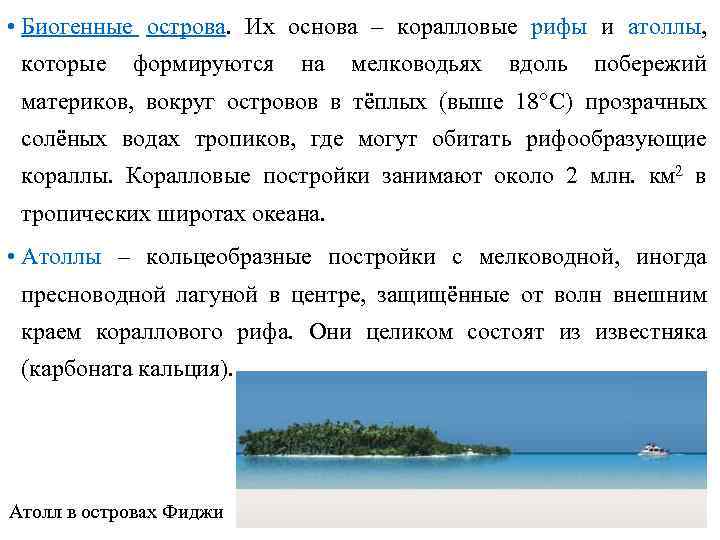 biological islands. Their basis is coral reefs and atolls, which form in shallow waters along the coasts of the continents, around islands in warm (above 18 ° C) transparent salty waters of the tropics, where reef-building corals can live. Coral structures occupy about 2 million km 2 in the tropical latitudes of the ocean. Atolls - ring-shaped structures with a shallow, sometimes freshwater lagoon in the center, protected from waves by the outer edge coral reef. They are made entirely of limestone (calcium carbonate). Atoll in the Fiji Islands

 Often, atolls form on the tops of seamounts when these peaks are located at least 20 m from the surface of the water. However, the foot of the reefs are often at great depths. The process begins with the formation of an underwater volcano, which eventually turns into a volcanic island. When volcanic activity ceases, the slopes of the cone are colonized by reef-forming corals down to a depth of 20 m. on the outer side of the terrace reef, a terrace is formed from the reef fragments. The heap of volcanic rocks creates a very large load on the ocean floor, the crust sags, the volcano slowly sinks, and the corals continue to build up the building, keeping the reef at the same level. Calcareous sediments are carried by waves, filling the cone between the reef and the volcano, forming a shallow ring-shaped lagoon. Gradually, the lagoon is covered with coral sands and it is often overgrown with coconut palms.
 If the ocean floor experiences upward movements, the sediment-filled lagoon is above the ocean surface. Such atolls are called raised. Nauru is a raised atoll. The sedimentary sequence is usually enriched in phosphorus salts of organic origin. These are wonderful phosphate fertilizers. Phosphorites are mined on the island within the former lagoon.
 Barrier reefs form breakwaters parallel to the outlines of the coast of the mainland or island. The largest of them is the Great Barrier Reef, which stretches for 2000 km parallel to the northeastern coast of Australia (Queensland). Great Barrier Reef O. Lady Musgrave in the Great Barrier Reef All coral islands are low (5-10 m above sea level), atolls 40-100 m high are very rare. The largest atolls are confined to the Marshall Islands and Tuamotu.
 Oceania - clusters of islands, the main part of which is located between 28.5 s. sh. and 52, 5 s. sh. - Hawaiian Islands in the north and Campbell Island in the south. Most of them are concentrated in equatorial and tropical latitudes. A significant part of them are grouped into archipelagos, but there are also isolated islands. The total area of Oceania is 1.26 million km 2, of which 87% of the area is occupied by about. New Guinea and the islands of New Zealand, and only 13% - all the rest. Historically, the division of Oceania into parts: Melanesia ("Black Island") - the southwestern part of Oceania, (New Guinea, Bismarck, Solomon, New Hebrides, New Caledonia, Fiji and other smaller ones); Micronesia ("Small Island") - the northwestern part (Marian, Caroline, Marshall, Gilbert, etc.); Polynesia ("Multi-Island") - the central part of the Pacific Ocean, (Hawaiian, Marquesas, Tuamotu, Tonga, etc.); islands of New Zealand - North and South, Sewart, etc.
 Climate. Oceania is located in the equatorial and tropical zones. The equatorial belt is dominated by ascending air currents and calm weather with especially heavy showers during the zenithal position of the sun. At what latitudes is the sun at its zenith? What days of the year? The tropical islands of the Northern and Southern Hemispheres are located in the Pacific Ocean regions with weak winds (regions of subtropical baric maxima). The main circulation process that forms the climates of the islands of this part of the ocean is the trade wind. What are the characteristics of a climate that is formed under the influence of the trade winds?
 In general, the climate of Oceania is maritime with significant amounts of precipitation during the year (in the west, more than 2000 mm), the maximum was recorded in the mountains of the Hawaiian Islands (the town of Wayaleale on the island of Kauai - 12,090 mm). However, in the east there are islands with an arid climate (for example, the Galapagos). Why on the islands of the Galapagos archipelago, located on the equator, the climate is not equatorial, but dry tropical trade winds? In western Oceania, tropical cyclones are born, accompanied by hurricane-force winds and downpours. The climate of most of the islands of Melanesia, hot and humid, is considered the most unhealthy climate on Earth. What type of climate is formed on the islands of Melanesia?
 Despite the significant differences in the nature of the islands, one can also notice similarities: the influence of the ocean affects the natural features of all the islands (marine climate, the wide distribution of landforms associated with the work of the sea, saline soils and waters); the river network is poorly developed: the rivers are short, the atolls are generally devoid of surface runoff; characterized by depletion of species composition and a high degree of endemism of flora and fauna; the mammals of the islands are often smaller, and the reptiles and birds are larger than on the continents; there are flightless birds.
 Population. Settlement history. The first inhabitants apparently appeared in Melanesia 20-30 thousand years ago, this part of the region was inhabited 5-6 thousand years ago. Humans entered Micronesia and Polynesia in the 1st millennium AD. e. and finally settled the islands by the XIV century. a brief description of population. There is a wide variety of anthropological types, languages, and cultures on the islands. Racial identity of the natives various parts Oceania is different: Melanesians and Papuans belong to the Australoid race, most Polynesians and Micronesians are of a mixed racial type.
 Now indigenous people makes up about half of the population. The islands were settled by settlers from different countries- England, France, USA, whose colonies they were for a long time. Lots of people from Asia. Most of the countries of Oceania have gained political independence, but their economy is still closely connected with the former metropolises. Most of the population is employed in agriculture, mining is also underway.
 Some islands are very densely populated and suffer from a lack of land, water, pollution from industrial waste and household waste. This problem is very acute in the atolls. On about. Nauru (raised atoll), where the richest deposit of phosphorites is developed in an open way, drinking water and food are imported. More than a third of the island's area is occupied by quarries. However, there are islands where there is little or no population. The surface of most of the island of Nauru is a quarry. remnants of the former
 Island natural complexes are especially vulnerable to their own (small size, isolation, extremely close internal connections of components). The intensive use of natural resources leads to a violation of the natural balance and often to the destruction and even destruction of entire islands. Especially great harm was done to the islands by nuclear weapons tests. Not only those on which the explosions were carried out were affected and became uninhabitable, but also many located at a relatively large distance from them. On many islands of Oceania, nature reserves and national parks have been created. In some of them, protected areas have existed since the 40-50s of the XX century (in New Zealand - from an even earlier time), but in most cases they were organized in the 70-80s of the XX century.
Features of the geological structure and topography of the bottom of the Pacific Ocean
In the relief of the Pacific shelf, there are:
- transgressive plains with subaerial relict relief (river valleys of the Bering Sea shelf and on the Yavan shelf);
- ridge landforms (East China Sea, Korean shelf);
- coral buildings (equatorial-tropical region);
- Antarctic shelf - the surface of the shelf is strongly dissected, underwater heights alternate with grabens;
- The continental slope is dissected by submarine canyons (North America, New Zealand, Australia, the continental slope in the Bering Sea, Antarctica).
Transitional areas of the ocean have different stages of development and levels of structural complexity. Transitional areas are located in a continuous strip along the western margin of the ocean, they include the following areas: Kurile-Kamchatka, Aleutian, Japanese, Indonesian-Philippine, East China, Melanesian, Bonin-Marian, Vityazev, Macquarie, Tonga-Kermadek. Here is the deepest trench - the Mariana Trench (11 thousand 022 m).
Ready-made works on a similar topic
- Coursework 460 rubles.
- Essay Natural features of the Pacific Ocean 270 rub.
- Test Natural features of the Pacific Ocean 200 rub.
The eastern part of the ocean contains the Central American and Peru-Chile transition regions.
Remark 1
All transitional areas are characterized by modern volcanism, they are seismic, and together they form the marginal Pacific belt of earthquakes and volcanism.
About 11% of the bottom area falls on mid-ocean ridges: South Pacific Rise; East Pacific Rise; Chilean uplift; Galapagos Rift Zone; the ridges of Juan de Fuca, Gorda, Explorer, Sala y Gomez, Nazca, Cocos, Carnegie.
The most significant ridges of the central and western parts of the Pacific Ocean floor have a common pattern: they form a system of arched uplifts that originate in the west and end in the southeast.
A striking feature of the tectonic structure and relief is the zones of oceanic faults, manifested in the relief in the form of complexes of consistently oriented linear depressions, grabens, and blocky ridges (horsts).
The basins and uplifts of the ocean floor are characterized by the earth's crust of the oceanic type.
A distinctive feature of bottom sediments is the presence of red clays. Only in the Pacific Ocean there are belts of siliceous diatomaceous oozes. A belt of siliceous radiolarian deposits is pronounced. In the southern and western parts of the ocean, coral-algal biogenic deposits are found. The Pacific Ocean contains foraminiferal silts, pteropod deposits, and iron-manganese nodules.
Climate conditions of the Pacific Ocean
The climate of the Pacific Ocean is determined by the circulation of the atmosphere, the patterns of zonal distribution of solar radiation, and the seasonal influence of the Asian continent.
Wind fields are formed in accordance with the distribution of baric centers. In the northern hemisphere, in temperate latitudes, strong westerly winds (in winter) and weak southerly winds (in summer) are common; northeast trade winds prevail in the subtropics and tropics. The equatorial zone is characterized by calm weather.
In the northwest of the ocean in the northern hemisphere, northeast and north monsoon winds (in winter), south monsoons (in summer) are established.
In the southern hemisphere, in the subtropics and tropics, the southeast trade wind dominates.
In the tropics, cyclonic activity causes the formation of tropical hurricanes. They originate more often in summer, east of the Philippines and move north and northwest through Taiwan and Japan. When approaching the Bering Sea, they fade.
Hurricanes originate in the coastal regions of the Pacific Ocean adjacent to Central America.
In the tropical and equatorial zones, the average annual temperature ranges from 25.5 to 27.5ºС. In the western part of the ocean, the climate is warmer than in the eastern part.
In the equatorial zone, there are bands of maximum precipitation; a relatively arid zone stretches along the equator.
To the east, in the tropical zone, aridity increases, and in the equatorial zone, the amount of precipitation decreases. The driest areas are adjacent to California, located in the Chilean and Peruvian basins.
The patterns of general air circulation determine the pattern of currents in the Pacific Ocean. The main streams are:
- Northeast Current,
- North Pacific Current,
- equatorial countercurrent,
- Kuroshio Current,
- alaska current,
- california current,
- trade wind,
- Southern Equatorial and Northern Equatorial currents,
- East Australian Current,
- the course of the West winds,
- peru current,
- currents of Cape Horn.
Remark 2
A large amount of precipitation falls on the surface of the Pacific Ocean, which reduces the salinity of the waters, especially at the equator, the western parts of temperate and subpolar latitudes.
The maximum salinity - 35.5-35.6% - is observed in tropical areas, where relatively small amounts of precipitation are combined with intensive water evaporation.
Ice formation occurs in the Antarctic regions. In the north, ice forms in the Sea of Okhotsk, the Bering Sea, and the Sea of Japan. The glaciers of South Alaska dump some of the ice into the ocean in the form of icebergs. Icebergs spread far to the north.
The water masses of the Pacific Ocean
In the Pacific Ocean, the following water masses are distinguished:
- Surface - depth 35-100 m, relative evenness of temperature, density and salinity.
- Subsurface - the border with intermediate waters ranges from 220 to 600 m. They are distinguished by increased density and salinity.
- Intermediate - the lower limit is at a depth of 900-1700 m. They have a relatively low temperature - 3-5ºС and salinity 33.8-34.7%.
- Deep - are formed due to the immersion of chilled waters in the Antarctic waters and spreading through the basins.
- Bottom - are at a depth of 2500-3000 m. Low temperature is characteristic - 1-2 ºС and salinity 34.6-34.7%. They form on the Antarctic shelf under conditions of strong cooling.
Flora and fauna of the Pacific Ocean
The flora and fauna of the Pacific Ocean is diverse and plentiful.
Phytoplankton consists mainly of microscopic unicellular algae - peridine and diatoms. The main part of the vegetation is concentrated in shallow water areas and upwelling zones.
In temperate and cold zones of the ocean, brown algae (kelp) are massively distributed. In the tropics, ficus, calcareous red algae are found, which, together with coral polyps, are reef-forming organisms.
The waters of the Pacific Ocean are rich in wildlife diversity. An important feature is the antiquity of most systematic groups and endemism. Many ancient sea urchins, horseshoe crabs, fish (Gilbertidium, Jordan). Only here live representatives of pogonophores.
Endemic species are also found among mammals: fur seal, dugong, sea lion, sea beaver.
Answer:
Pacific Ocean- the largest in area, the deepest and most ancient of the oceans. Its main features are great depths, frequent movements of the earth's crust, many volcanoes at the bottom, a huge supply of heat in its waters, and an exceptional diversity of the organic world. Geographical position ocean. The Pacific Ocean, also called the Great Ocean, occupies 1/3 of the surface of the planet and almost 1/2 of the area of the World Ocean. It is located on both sides of the equator and 180° meridian. This ocean separates and simultaneously connects the coasts of five continents. The Pacific Ocean is especially wide near the equator, so it is the warmest on the surface. In the east of the ocean, the coastline is poorly dissected; several peninsulas and bays stand out. In the west, the coasts are strongly indented. There are many seas here. Among them there are shelf ones, located on the continental shelf, with depths of no more than 100 m. Some seas lie in the zone of interaction of lithospheric plates. They are deep and separated from the ocean by island arcs. From the history of ocean exploration. Many peoples inhabiting the Pacific shores and islands from ancient times made voyages on the ocean, mastered its riches. The beginning of the penetration of Europeans into the Pacific Ocean coincided with the era of the Great Geographical Discoveries. The ships of F. Magellan for several months of navigation crossed a huge body of water from east to west. All this time, the sea was surprisingly calm, which gave Magellan reason to call it the Pacific Ocean. Much information about the nature of the ocean was obtained during the voyages of J. Cook. A great contribution to the study of the ocean and its islands was made by Russian expeditions led by I. F. Kruzenshtern, M. P. Lazarev, V. M. Golovnin, and Yu. F. Lisyanskii. In the same 19th century complex studies were carried out by S. O. Makarov on the ship "Vityaz". Regular scientific voyages since 1949 were made by Soviet expeditionary ships. A special international organization is engaged in the study of the Pacific Ocean.
Features of nature. The relief of the ocean floor is complex. The continental shelf (shelf) is well developed only off the coast of Asia and Australia. Continental slopes are steep, often stepped. Large uplifts and ridges divide the ocean floor into basins. Near America is the East Pacific Rise, which is part of the system of mid-ocean ridges. At the bottom of the ocean there are more than 10 thousand individual seamounts, mostly of volcanic origin.
The lithospheric plate, on which the Pacific Ocean lies, interacts with other plates at its boundaries. The edges of the Pacific Plate plunge into a tight space of trenches that encircle the ocean. These movements give rise to earthquakes and volcanic eruptions. Here lies the famous "Ring of Fire" of the planet and the deepest Mariana Trench (11022 m). The climate of the ocean is varied. The Pacific Ocean is located in all climatic zones, except for the northern polar one. Above its vast expanses, the air is saturated with moisture. Up to 2000 mm of precipitation falls in the equator region. The Pacific Ocean is protected from the cold Arctic Ocean by land and underwater ridges, so its northern part is warmer than the southern. The Pacific Ocean is the most restless and formidable among the oceans of the planet. Trade winds blow in its central parts. In the western - monsoons are developed. In winter, a cold and dry monsoon comes from the mainland, which has a significant impact on the climate of the ocean; some of the seas are covered with ice. Often, devastating tropical hurricanes - typhoons ("typhoon" means "strong wind") sweep over the western part of the ocean. In temperate latitudes, storms rage throughout the cold half of the year. Westerly transport of air prevails here. Most high waves heights up to 30 m are noted in the north and south of the Pacific Ocean. Hurricanes raise entire water mountains in it. The properties of water masses are determined by the characteristics of the climate. Because of long distance ocean from north to south, the average annual water temperature on the surface varies from -1 to + 29 ° С. In general, precipitation in the ocean prevails over evaporation, so the salinity of surface waters in it is somewhat lower than in other oceans. The currents in the Pacific Ocean are consistent with their general scheme in the World Ocean, which you already know. Since the Pacific Ocean is strongly elongated from west to east, it is dominated by latitudinal water flows. Both in the northern and southern parts of the ocean, ring-shaped movements of surface waters are formed. The organic world of the Pacific Ocean is distinguished by an extraordinary richness and diversity of plant and animal species. Half of the total mass of living organisms of the oceans lives in it. This feature of the ocean is explained by its size, variety of natural conditions and age. Life is especially rich in tropical and equatorial latitudes near coral reefs. There are many salmon fish in the northern part of the ocean. In the southeast of the ocean near the coast of South America, huge accumulations of fish are formed. The water masses here are very fertile, they develop a lot of plant and animal plankton, which feed on anchovies (herring-like fish up to 16 cm long), horse mackerel, mackerel and other fish species. Birds eat a lot of fish here: cormorants, pelicans, penguins. Whales, fur seals, sea beavers live in the ocean (these pinnipeds live only in the Pacific Ocean). There are also many invertebrates - corals, sea urchins, shellfish (octopus, squid). The largest mollusk lives here - tridacna, weighing up to 250 kg. In the Pacific Ocean there are all natural belts, except for the north polar one. Each of them has its own characteristics. The northern subpolar belt occupies a small part of the Bering and Okhotsk seas. The temperature of the water masses here is low (down to -1°C). In these seas, there is an active mixing of waters, and therefore they are rich in fish (pollock, flounder, herring). There are a lot of salmon fish and crabs in the Sea of Okhotsk. Vast territories cover the northern temperate zone. It is strongly influenced by westerly winds, storms are frequent here. In the west of this belt lies the Sea of Japan - one of the richest in diverse species of organisms. In the equatorial belt at the boundaries of currents, where the rise of deep waters to the surface increases and their biological productivity increases, many fish live (sharks, tuna, sailboats, etc.). In the southern tropical Pacific off the coast of Australia is a unique natural complex Great Barrier Reef. This is the largest "mountain range" on Earth created by living organisms. It is comparable in size to the Ural Range. Under the protection of islands and reefs in warm waters, coral colonies develop in the form of bushes and trees, columns, castles, bouquets of flowers, mushrooms; corals are light green, yellow, red, blue, purple. Many mollusks, echinoderms, crustaceans, and various fish live here. Types of economic activity in the ocean. More than 50 coastal countries are located on the shores and islands of the Pacific Ocean, in which approximately half of humanity lives.
Rice. 43. The relief of the bottom of the Pacific Ocean. What are the structural features of the bottom topography?
The use of the natural resources of the ocean began in antiquity. Several centers of navigation arose here - in China, in Oceania, in South America, in the Aleutian Islands. The Pacific Ocean plays an important role in the life of many nations. Half of the world's fish catch comes from this ocean (see Figure 26). In addition to fish, various shellfish, crabs, shrimp, and krill make up part of the catch. In Japan, algae and mollusks are grown on the seabed. In some countries, salt and other chemicals are extracted from sea water and desalinated. Metal placers are being developed on the shelf. Oil is being produced off the coast of California and Australia. Ferromanganese ores have been found at the bottom of the ocean. Important sea routes pass through the greatest ocean of our planet, the length of these routes is very large. Navigation is well developed, mainly along the coasts of the mainland. Human economic activity in the Pacific Ocean has led to the pollution of its waters, to the depletion of certain types of biological wealth. Yes, to late XVIII V. mammals were exterminated - sea cows (a type of pinnipeds), discovered by one of the participants in the expedition of V. Bering. On the verge of extinction at the beginning of the 20th century. there were seals, the number of whales decreased. Currently, their fishery is limited. A great danger in the ocean is water pollution by oil, some heavy metals and waste from the nuclear industry. Harmful substances are carried by currents throughout the ocean. Even off the coast of Antarctica, these substances have been found in the composition of marine organisms.