In the summer, the combined team of the MAI Tourist Club and the State Customs Committee “Citadel” (Brest) visited the mountains of the eastern part of the Central Tien Shan. Despite the fact that not all of the initial plans were realized, the campaign was a success. We got acquainted and fully imbued with the area, passed several beautiful passes and climbed the three highest peaks of the Tien Shan. See below for a photo report of our trip.
I'll tell you a little about what we wanted and what happened to go through. The acclimatization stage went according to plan. It included the passage of two survey passes of the Seven Muscovites (1B, 4130) and Chontash (2B, 4570) and the first ascent to the summit of Explorers of the Tien Shan (4490). Then, having reached the South Inylchek glacier, we climbed up it and through the Komsomolets glacier climbed out to the Schmidt Plateau pass (3B, 5270), which had not been visited for a long time. From its saddle we passed the traverse of the untrodden peak 5650 and, ahead of schedule, descended through the Proletarsky tourist glacier to MAL on South Inylchek.
At the next stage, we planned to pass three high-altitude traverses. But due to problems with my back and the paramount desire of the team to climb the seven-thousanders, they refused to continue the planned route. Later we switched to separate ascents in the upper reaches of the Southern Inylchek, sometimes for convenience dividing into subgroups. As a result, through the Razorvanny glacier we climbed the Eastern Saddle of Khan-Tengri (5800 m) and made an attempt to climb into. Tent Western (6511), climbed Khan-Tengri (7010) and Pobeda (7439), climbed the western peak of the peak of Military Topographers (6815).
The way from the base camp to the Semenovsky glacier takes 2.5 - 3 hours. The tents of the first camp do not stand directly at the confluence with the South Inylchek, but a little lower, hiding from large avalanches from Khan Tengri and Chapaev Peak behind a rocky spur.
Feeling some euphoria from going on the route, we got carried away and talked until late in the evening. The degree in the blood also interfered with sleep. As a result, we passed out at ten, and at midnight got up for the early passage of a narrow and dangerous section between the peaks of Chapaev and Khan-Tengri, popularly called the bottle.
Evening snow covered all traces. The ascent began almost in the dark. The flashlight snatched out only 50 meters of the glacier in front of my feet. We went straight up, focusing on the silhouettes of large mountains. I was on Khan Tengri 8 years ago, but now everything has changed. Instead of deep snow - firn, powdered with snow. Yes, and we went down for the most part along the opposite side.
Before the beginning of the dangerous place we were overtaken by a bunch. One of the men in its composition was on Khan last year and in general terms he imagined where the standard ascent path passes.
The surrounding landscape brightened, and the mountains woke up.
On the way to the neck of the bottle from the Chapaev Peak, an avalanche began, which went lower, but kept us in suspense and covered us with snow dust.
A little higher we saw a tent with a crazy man who decided to put it in such a place.
Tent - dot in the center of the frame
Someone is coming down
Camp 5300 is located a little above the icefall of the Semenovsky glacier. Considering yesterday's gatherings, we could not deny ourselves the desire to boil tea there and take a nap for an hour.
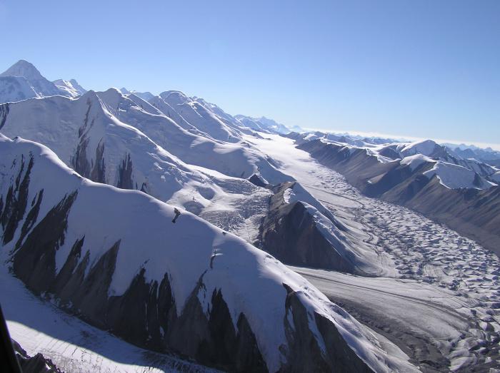
The upper reaches of the Southern Inylchek and the peak of the Military Topographers (6873)
The rest cheered us up a little and we climbed relatively fresh into the bergschrund under the Western Saddle of Khan-Tengri. Here, at an altitude of 5800, the tents of the assault camp are located. Further route along western ridge Khan-Tengri is almost entirely hung with stationary railings. There are also small sites for spending the night at 6350 (for one tent), 6400 (for two tents), at 6600 (for 1 tent), near the summit.
Compared to 2009, now most of the tents at 5800 are located in a wide covered berg under the saddle, and caves are being torn off there. It's less windy and safer. 8 years ago, from the saddle to the north, almost from under our feet, a giant cornice flew off, breaking off right along the path with poles.
A simple ascent to Khan Tengri could not give normal acclimatization. Therefore, we decided to climb with bivouac equipment to 6400, set up a tent, go to the top, and then descend and spend the night. Maybe in terms of load, such a plan was not entirely ideal, since it would be more competent to spend the night at 6400 first, and then climb the mountain the next day. But we were afraid of the worsening weather that the forecast promised. We decided to make the most of our first outing.
We packed up the camp and at about 3 o'clock in the morning we went up from 5800. I was lucky at the start to slip through a group of foreign climbers, and Misha stood behind them and later bypassed them one by one. On the way to 6400 I overtook several people, whom I didn’t see more on the way to the top and on the descent, they probably turned back.
In 3 hours I climbed to the site at 6400, where one tent was already standing. The weather was unpleasant, visibility was limited, and a gusty wind was blowing. Therefore, I did not dare to set up our tent alone and started leveling and completing the site. Together with Misha, who soon came up, we set up and stretched out a tent, in which we left our belongings and equipment.
It must be said that climbing Khan-Tengri along the classic route from the Western Saddle is not quite sporty. The almost continuous thread of the railing allows you to climb and descend from the top in almost any weather. Modern equipment reliably protects even from strong winds, and the lack of visibility deprives you of pleasure, but does not interfere with the ascent. So we, of course, remembering the “cold - wind” from Vladimir Stetsenko, decided that there was no reason not to go upstairs.
If up to 6400 even with a backpack I felt quite fresh, then continuing the ascent already light, I noticed that the pace had dropped. Misha, on the contrary, added and went a couple of pitches ahead. I tried to find motivation to climb to the top, where I had already been before, along a fixed route and in the absence of visibility. I persuaded myself to continue climbing for the sake of further acclimatization. In front of the “trough” I caught up with Misha, who ran into a line on the railing.
We clearly lacked acclimatization, as the previous summit was a traverse of the Baglynka peak (5650) with an overnight stay at 5300. I looked at the people in front, going noticeably slower and still resisting and continuing to move up. And I understood that if they endure, then I can endure a little.
We went to the top together with the people of Alma-Ata. The climb from 6400 took about 5 hours. Physically and psychologically, he was given hard. After a couple of weeks, we went to Pobeda easier and with much more pleasure. I dragged a heavy DSLR upstairs for nothing, taking only a couple of shots. We never saw the northern Inylchek behind the clouds.
Misha on top
We went down to the tent at 6400, where we had lunch and settled down to rest. The forecast was predicted to be negative, but we did not deny ourselves a high overnight stay.
We woke up at one in the morning and hurried down. Having passed the bottle before sunrise, at 5 am we were at South Inylchek.
On the left is Pogrebetsky Peak (6527)
Meanwhile, our main team climbed the East Saddle of Khan-Tengri through the icefall of the Razorvanny glacier. And having made an attempt to climb the Western Tent, in bad weather, she was forced to turn around and go down to the camp on the saddle. And there was no time left for a second attempt, as the deadline for our meeting in MAL was running out.
Vazha Pshavela (6918) and Nehru (6742)
Khan Tengri (6995)
Having reunited with the team, they began to jointly build further plans. It became clear that we no longer had time to continue the originally planned route and in the end go to Pobeda. As a result, we decided that it would be easier and more interesting to go to individual peaks. In addition, at that moment there was still hope for a possible traverse of the Victory.
The guys who were not on Khan decided to go there. And Misha and I were joined by Vanya, who was already a snow leopard, and we planned a walk to the upper reaches of the Zvezdochka glacier.
Here, in the Inylchek region, the main focus is on Khan Tengri. This year, more than a hundred people climbed from the south alone. Another part of the people is trying to climb the Pobeda Peak. The rest of the interesting and easily accessible peaks, which have a not so attractive height, are deprived of attention. Climbers visited many six-thousanders of the Meridional Ridge 1-2 times. In the area of the glaciers Komsomolets, Shokalsky, Putevodny and other glaciers there are a lot of untrodden five-thousanders. The third highest peak of the Tien Shan - the peak of the Military Topographers (6873 m) is climbed extremely rarely, 1-2 groups in 5 years.
Since we didn’t have any descriptions, we decided with our subgroup to go up to the upper reaches of the Zvezdochka and already there decide what to do next. They planned to choose between Military Topographers and Eastern Victory, depending on what they saw.
The path to the upper reaches of the Zvezdochka leads along a marked path to the icefall at the turn of the glacier. Then it passes by the first camp of Pobeda under the pedestal of the Abalakov route and further up under the walls of Eastern Pobeda.
Abalakov's route goes from left to right
In the center of the frame, the western peak of the peak of the Military Topographers
There are many lakes in the central part of Zvezdochka. The glacier is broken not strongly. A small icefall opposite the spur of Shipilov Peak goes along the right side of the glacier. In order not to fall through, after dinner, we put on snowshoes and went further in them.
Western Summit of Military Topographers Peak (6815)
Avalanche from the Victory balcony. To the right is Zhuravlev's route
The rocky walls of the Eastern Victory impress with their steepness and scale. The sun practically does not illuminate them. Of the four routes laid here, none is repeated.
About 4 kilometers did not reach the Chonteren pass, located between the Eastern Victory and the Military Topographers the day before. In the morning Misha complained of being unwell. Probably not fully recovered after Khan Tengri, and yesterday at 9 o'clock was not easy. We approached the pass take-off, but did not rise higher. Since they considered that the rest will be much more productive below.
The next day, the condition and mood is excellent. Chonteren climbed almost on foot, hanging 50 meters of railings at the top of the takeoff. From the Chinese side, too, there are no big difficulties. Therefore, the tourist category of the pass 3B is very conditional.
Shipilov Peak (6201)
The advantage of the route to the summit of Eastern Pobeda (6762 m) is that from the saddle of the pass (5500 m) it is light and with the current state of snow it takes a day. We, having a certain margin of time, decide to go to the peak of the Military Topographers located further.
Behind the crest to Eastern Pobeda
A narrow cornice ridge goes straight from the pass in the direction of the peak of the Military Topographers. Walk along it in a bundle small group pure pleasure.
Above the ridge expands, turning into a snowy slope, which leads to a small plateau. On the edge of the plateau there is a group of picturesque ice seracs. Vanya dubbed them Julie's, since in Anatoly's reports he often saw similar landforms. Large pieces of ice break off the edge of the plateau and gradually slide into the abyss. While lunch was being prepared, we had time to walk and climb a little.
Victory Array
Walls of Military Topographers Peak
Between the seracs is Pobeda Peak
The camp was set up at an altitude of 6050 under the slopes leading to the western ridge of the Military Topographers. While the guys were setting up the tent, I managed to trail up and take some pictures of the mountain. The entire path of the traverse of Valery Khrishchaty's team from Pobeda to Khan opened up before my eyes.
Peaks of the legendary traverse in one panorama
Panorama from Pobeda to Khan
The plans to traverse the summit that had arisen were postponed until future trips, since Misha, motivating the decision by the preservation of strength for the Victory, refused to accompany us on the ascent.
In the morning, new adventures awaited us. About 5 o'clock shook a couple of times. As it turned out later, these were the echoes of a seven-magnitude Chinese earthquake. Where there was a small bergschrund the day before, a 3-meter ice wall appeared. Our entire plateau sank, deep ice funnels formed on the slope. There have been landslides here and there. As the guys from our second subgroup, who were descending from Khan at that moment, later said, avalanches descended from Chapaev and Khan Tengri at the same time, a cloud of dust flew to Inylchek. And just a few minutes before that, they managed to leave the Semenovsky glacier around the corner.
During the evening reconnaissance, the first rock gendarme of the western ridge of the Military Topographers seemed rather difficult. For its passage it would be necessary to hang a railing. Therefore, we decided to climb the ridge in a new way, leaving already above the gendarme.
South view
The amount of snow on the slopes was decent. Sometimes there were spots of crust, but mostly we had to trail and not forget about the avalanche danger. It went hard. Initially, having taken with them an additional rope and some kind of rock equipment, they left it all on the shelf. Because we realized that if we encounter serious technical difficulties, then in the current state we will not make it to the top. And everything that is easier, we will climb in a bunch.
The upper reaches of the South Inylchek
From the place of exit to the ridge under the rocky rise to the second gendarme there is a long section with cornices. We were more embarrassed not by them, but by the real chances to leave with an avalanche on the sheer cliffs of the Chinese side. At some point, they even tied up the entire length of the rope in order to be able to alternately release each other and tuck it behind protruding stones.
The weather didn't help the climb, but it didn't make us turn around either. Hoods and windproof masks saved from the gusty wind. Having passed the cornices, we approached the rocky gendarme. The lower part was climbed. I climbed higher, tensing a little in the fireplace, and threw off the rope to Vanya.
Above the gendarme, the crest expands and becomes simple. But the wind and deep snow made it difficult to go. We climbed to the Western summit of the Military Topographers (6815 m) in the absence of visibility. In the tour, they found a note from Kirikov-Oleynik-Parshin dated 2005, who, in turn, removed the note from Sergey Lavrov from 1999.
According to the navigator, there were still 400 meters and 60 in height to the Main Peak, but there were no thoughts of going there without visibility.
It cleared up on the descent
We went down to camp 6050, where Misha met us with an awesome borscht, by 18:30 in the evening.
We got up early in the morning, went down to Zvezdochka and ran to the base camp, where we were already met by the guys who had successfully climbed Khan Tengri.
In the evening, an Iranian woman came to talk to us, which the guys actually saved on the Khan. According to stories, during an overnight stay at 6400, at 8 pm, she went down to the ledge to their tents and remained seated. The girl no longer had the strength to continue the descent. Initially, she refused the invitation to go into the tent, as well as the offer of tea. But in the end they put her in a sleeping bag, warmed her, gave her a drink and in the morning normal condition sent down.
After resting for a couple of days, they began to gather for the Victory. The weather is over by now. After August 10, not heavy but frequent snowfalls began, and winds blew up above. We understood that there could be no eternal bad weather and a window would definitely appear, we only needed to guess the exit to Vazha Pshavela by this moment. And from there to the top day. Part of the team also did not want to give up the idea of a traverse so easily, so they took an additional arc tent upstairs, all together intending to live in a tent.
There are seven of us left on the team. Zhenya flew to work after trying to climb the Western Tent, and Maxim after climbing Khan Tengri. And three guys from Novosibirsk and Moscow joined us. We decided to go up the mountain autonomously, but climb together, trying to help each other.
Dmitry Grekov gave us a radio station and further helped by maintaining and reporting the current weather forecast. This attitude was very pleasant, especially since we were not Ak-Sai's clients.
While the weather was on the Tien Shan, the people, believing that the time had not come, acclimatized on the Khan, rested and talked in the base camp. As a result, when everyone was ready to go up, the weather turned off. Before us, three people climbed through Vazha, who unsealed the mountain this season, and four guys from the Novosibirsk team passed the traverse, climbing the Zhuravlev route and descending the classic.
We went upstairs on August 14th, believing that just in time for the possible window on the 18th-19th, we would row up to Vazha.
The first obstacle on the way to the summit is the icefall of the Wild Pass. Unlike the further route, every year the first climbers on the mountain hang it with new railings. The icefall itself is normal. Above a steep step in one and a half ropes, everything is walked on foot. Dangerous approach under the hanging dumps and ice at the beginning of the railing. Therefore, it is advisable to pass the icefall either early in the morning or in the late afternoon, when the peak solar activity behind.
Leaving the base camp after lunch, we stopped for the night about a kilometer from the icefall. It is scary to stop closer because of possible avalanches and landslides from the slopes of Pobeda.
Having passed the icefall in the morning, we went through the snowy fields to a small trough on the Dikiy pass. While dinner was being prepared, the stragglers approached. Since the weather was not promised for tomorrow, the goal on this day is to climb to the caves at 5800, in order to comfortably wait for it to improve there.
View of the Western Col of Khan-Tengri
Exit to the Wild
The slopes above the Wild are gentle, but overloaded with snow and avalanches. Plots of deep snow alternate with a firn board. Put on beepers and snowshoes. Trying not to cut the slope, we went up, breaking the path.
In the center of the frame we passed the traverse of the top of the Bagpipe (5650)
According to the information we have, two caves were dug on the slopes for three and six people. Coming to the bottom of them at an altitude of 5700, as it later turned out to be less, they expanded it to seven people. Three guys from the parallel group went to spend the night higher.
By evening the weather had deteriorated and it was very cold. While expanding our cave, we met a team of people descending from above. The weather prevented them from going to the top. To the question: “Where are you from?”, Ilya, who led the group, replied: “From hell!”.
At night, they dug up the entrance to the cave a couple of times. The whole next day the revenge continued. Our walkie-talkie quickly sat down. Left without weather and without a forecast, they began to try to get information by satellite phone. In response to an SMS with a request, one of our friends wrote that heavy rains were expected at Pobeda, another sent a long text in English, copied from the site, saying that everything would be very bad, but not without specifics. We were also interested in specific figures for cloudiness, precipitation and wind strength.
Seeing what was happening on the street, and having no perspective, the idea of a traverse of the summit was finally abandoned, switching to a radial ascent. Extra things and an additional tent were left in the cave and closer to dinner on August 17, when it was a little more visible, we went upstairs.
There are several rocky belts on the ridge of Vazha from 5800 to peak 6918. The first one is at altitudes of 5800 - 6000, the second one is 6100 - 6250 and a couple of small areas above 6400. traditional places under the tent there is at 6100 under the protection of small stones, and at 6400. There are no places protected from the wind. In case of heavy snowfalls, the rocks at 6100 and 6400 do not fully protect against avalanches either. In fact, a small arc tent can be put up almost everywhere, breaking off part of the slope. You will have to tinker with the platform for the tent.
The rocky sections of the ridge are fixed with railings. But they are not updated and only sometimes they are duplicated by the forces of enthusiasts with newer ropes. In some places the rope is broken or without braid. The rocks are simple, so it is better to climb on your own, insuring yourself with a jumar.
In the evening we went to the sites at 6400. Three guys walking in parallel found a ready place for their arc redfox. We began to expand the site next to our large tent. After some time, they came across a human body, as it turned out later, perhaps it was Alexander Popov, who was covered here in 2012 by an avalanche. Having dug it with snow, they went 50 meters to the side and dug a place on the slope.
We are building a site at 6400
The bodies of those who died at the Victory are a little tense. It is clear that there is simply no strength and opportunity to go down. But it's one thing when a person is wrapped in an awning and a tent and conditionally buried away from the path. Another, when at 7250, in the trough under the gendarme, a dead person just sits. It is not so difficult to wrap it in an awning, but you need to know about it in advance and have an awning with you. On a ridge covered with fir, you can’t just bury it in the snow and you won’t take off your puff.
Behind the peak of Nehru
The Tien Shan mountains excite the imagination of many, many travelers. How I want to come here, look at the snow caps with my own eyes, feel the power and strength of this place!
To be honest, not everyone succeeds. Why? As a rule, there may be several reasons, but among the main ones I would like to highlight the following. Remember where the Tien Shan is located. Agree, this is far from the center of the intersection of the main tourist routes of the planet, which means that getting to this point on the planet is both long and expensive. Only the most desperate can afford it. Secondly, in order to go to conquer the grief of the Tien Shan, considerable physical preparation is needed. For a beginner, such a journey can actually be dangerous.
However, this article will not only tell about where the Tien Shan is located. In addition, the reader will receive valuable information about many other things. For example, about characteristic features of this object, its climate, legends and myths, flora and fauna.
Section 1. General Information
The Tien Shan mountains, photos of which can be found in almost any atlas that tells about geographical features of our planet are located in Central Asia on the territory of several states at once (Kyrgyzstan, China, Kazakhstan and Uzbekistan).
A significant part of the western range is located in Kyrgyzstan, the eastern half comes within China, the northern and western ends are in Kazakhstan, and the southern extreme points are within the borders of Uzbekistan and Tajikistan.
It should be noted that the Tien Shan ridge lies mainly in latitudinal and sublatitudinal zoning. These are one of the highest mountains in the world, among which there are many peaks over 6.0 thousand meters high.
The highest points include Pobeda Peak (about 7440 meters), rising on the border of Kyrgyzstan and China, and Khan Tengri (almost 7000 meters), located in Kyrgyzstan near Kazakhstan. It is even difficult for the inhabitants of the flat territories to imagine how it is to live at the foot of giant mountain giants, the peaks of which rise far above the level of cloud formation.
In general, the mountain system is divided into several regions: Northern, Western, Southwestern, Eastern, Inner and Central.
Section 2. Blue Mountains, or Tien Shan. Highland climate
The climate of this system belongs mainly to the sharply continental type, characterized by hot and dry summers with little precipitation.
Winter is characterized by harshness and high temperature fluctuations, low cloudiness and excessive dryness of the air. In the mountains, there is a significant duration of sunshine, which is up to 2700 hours per year. Of course, such data is unlikely to say anything to an ordinary person, so for comparison, we note that, for example, in Moscow, the average annual figure is only 1600 hours. The change in these values is influenced by high-altitude cloudiness and the complexity of the landscape.
The amount of precipitation depends on zonality and increases with elevation. The least precipitation falls on the plains (150-200 mm per year), and in the regions of middle mountains this figure already reaches up to 800 mm per year.
Most of all it is necessary for the period of spring and summer. The high dryness of the air affects the formation of snow cover, which differs in different areas. For example, the Tien Shan mountains in Kazakhstan (northwestern slopes) have a snow line that forms at an altitude of 3600-3800 meters, in the Central part - at an altitude of 4200-4500 meters and 4000-4200 meters in the Eastern regions. That is, the height largely determines the conditions for the formation of the climate of a particular area.
A large accumulation of snow and ice on the slopes of the Tien Shan mountains with the onset of heat can lead to dangerous avalanches. That is why travelers should be extremely careful.
Section 3. Geographic features
The Tien Shan Mountains are located in Central and Central Asia and are among the most high mountains alpine folding throughout the planet. At an altitude of 4000 m, traces of ancient leveled surfaces have been preserved.
It should be noted that the Tien Shan mountains, the photos of which literally amaze with their splendor, are still in tectonic and seismological activity.
It is hard to imagine that more than thirty peaks of the mountain range have a height of more than 6000 meters. Of these, the highest are Pobeda Peak (7439 m) and Khan-Tengri Peak (almost 7000 m). The length of the system from west to east is 2500 km.
Formed from igneous, and intermountain depressions - from sedimentary rocks. The height of the Tien Shan mountains, of course, leaves its imprints on their features. The main part of the slopes has a high-mountainous relief with glaciation forms and scree rocks.
It has been established that at an altitude of over 3000 m, the permafrost zone begins. Between the mountain systems there are intermountain basins (Issyk-Kul, Naryn and Fergana).
To date, deposits of minerals have been discovered in the depths of the Tien Shan: cadmium, zinc, antimony and mercury. And in the depressions - oil reserves. Numerous glaciers and avalanche-prone snowfields. If we imagine where the Tien Shan is located from an economic point of view, it immediately becomes clear how great the role of this mountain system in the welfare of neighboring states.
In addition, it should be noted that Chu, Tarim, Ili, etc.) and lakes (Issyk-Kul, Chatyr-Kul and Song-Kel) belong to the water bodies of internal flow, which means that they have a significant impact on the climate of the Tien system -Shan. Kazakhstan, Kyrgyzstan, China and Uzbekistan have long since learned to use these features to their advantage for industrial purposes.
In general, the mountain chain consists of the following orographic regions:
- Northern Tien Shan, including the ranges of Kirghiz, Ketmen, Kungei-Alatau and Zailiyskiy Alatau;
- Eastern Tien Shan - Borohoro, Boglo-Ula, Kuruktag, Sarmin-Ula, Iren-Khabyrga, Karlytag Halyktau;
- Western Tien Shan - Talas Alatau, Karatau, Ugam, Pskem and Chatkal ranges;
- Southwestern Tien Shan: the southwestern part of the Fergana Range and the mountains surrounding the Fergana Valley;
- The Inner Tien Shan is located within the Kyrgyz Range, the Fergana Range, the Issyk-Kul Depression, the Kokshaltau Range and the Akshiyrak Mountain Range.
To the west of the Central regions, three mountain ranges are formed, separated by intermountain depressions and connected by the Ferghana Range. The eastern region of the Tien Shan consists of two mountain ranges up to 5000 m high, separated by depressions. Flat elevations up to 4000 m are typical for this area - syrty.
The Tien Shan mountains have a glaciation area of 7300 sq. km. The largest glacier is South Inylchek. A significant area is occupied by mountain steppes and semi-desert. The northern slopes are mostly covered coniferous forests and meadow-steppe, which pass higher into subalpine and on syrts - a landscape of cold deserts.
Section 4. The height of the Tien Shan mountains: myths, legends and features of the origin of the name
Many inquisitive travelers know that this name means “Heavenly Mountains” in Chinese. According to the Soviet geographer E.M. Murzaev, who studied the geographical terminology of the Turkic language, this name is borrowed from the word Tengritag ("Tengri" - "divine, sky, God" and "tag" - "mountain").

The Tien Shan, photos of which are quite common in periodicals, are famous for many legends associated with the description of certain places, most likely representing local attractions. Both the first and second stories in this section are about the Alatoo mountain range, located in the northern region of the Tien Shan.
Manchzhypy-Ata
One of the world-famous sights of Alatoo is the beautiful valley of the sacred springs of Manchzhypy-Ata, which is a popular place of pilgrimage. Here is the mazar of the great teacher of Sufism and the holy propagator of the Islamic faith among the nomadic Kyrgyz. Manchzhypy-Ata is not a person's name. So in various Turkic languages they called a respectable person, the patron of the area and wanderers, the righteous or the owner of fertile pastures. The valley consists of many gorges, from the ground of which miraculous springs gush. Each of them is considered healing, and their unusual properties have been proven by several leading experts on the planet at once.
Of course, in ancient times, these springs could also serve as a watering place for animals. But over time, the preacher of Islam was endowed with the miraculous powers of the owner of the springs.
Those who happened to visit the Tien Shan mountains in Kyrgyzstan, whose photos are especially breathtaking, must have heard the statements of local experts that springs endow those in need with the gift of family well-being, bestow knowledge and insight, and relieve infertility.
Tale of Alatoo
This tale refers beautiful place, located in the seasonal channel of rain mudflows flowing from the foothills of Terskey-Alatoo to Lake Issyk-Kul. Despite the fact that the clay cliffs of the gorge, overgrown with shrubs, at first look dull, looking closely, you can be surprised how much they change their appearance and appear in all their splendor.
Thanks to this, the name of the canyon "Fairy Tale" appeared. A fantastic world opens up here: multi-colored rocks of bright shades are frozen in unusual shapes, and natural statues of limestone and sandy rocks grow out of the ground, similar to prehistoric inhabitants or the ruins of castles.
The legend about this miracle of nature appeared recently. It says that the beauty of the gorge is unique, and if you come back here again, each time the gorge will look different. That is why excursions here are arranged with enviable constancy, and the flow of travelers has not dried up for many years now.
By the way, not everyone knows that in addition to Alatoo, the name of the ridge has several more options - Atatau, Altai and Alai, which means "Motley Mountains" in Turkic. Most likely, this is a description of the entire territory of the Northern Tien Shan, which is famous for its inconstancy and diversity. Here, green meadows intertwine with rivers, snow-white peaks coexist with multi-colored rocks covered with coniferous forests and bright foothill steppes.

Section 5 Inland Waters
The Tien Shan mountains in Kyrgyzstan, as, indeed, in all other countries, are the territory of the formation of runoff, where many rivers originate from glaciers and snowfields of the glacial-nival zone and end in endorheic and inland lakes or form "dry deltas" , when the waters are absorbed into the sediments of the plains and go to irrigation.
All the main rivers that have their sources in the Tien Shan mountains belong to the basins of the Syrdarya, Talas, Ili, Chu, Manas, etc. The rivers are fed by snow or glaciers. The runoff peak is observed in the spring-summer period. The waters are used to irrigate not only the interior valleys and depressions, but also the neighboring plains.
Large lakes of the mountain system are located at the bottom of intermountain basins and belong to the tectonic period. Such reservoirs are the salt lake Issyk-Kul and the alpine lakes Chatyr-Kol and Son-Kul, almost always covered with ice. There are also cirque and near-glacial lakes (Merzbacher). The largest body of water in the Eastern region of the Tien Shan is Bagrashkel, connected with the Kanchedarya River.
There are many small reservoirs, most of which are deep with steep banks and have a dam-dam origin (Lake Sary-Chelek).
Section 6. Area of glaciation
The number of glaciers in the mountain system is more than 7700. Among them there are valley, hanging and cirque types.

The total area of glaciation is quite impressive - over 900 square meters. km. The Terskey-Alatau ridge is characterized by glaciers of flattened peaks, consisting of underdeveloped moraine formations.
The Tien Shan mountains form glaciers at a continuous pace. This means that the slowly retreating part is being replaced at the same speed by others.
During the global ice age, this entire surface was covered with a thick layer of ice. Until now, in different mountainous regions of the world, one can find the remains of general glaciation - ramparts, moraines, cirques, troughs and high-mountain glacial lakes.
Note that without exception, all river systems Central Asia have origins from the well-known Tien Shan glaciers. One of them is the large river Naryn (Kyrgyzstan). The Tien Shan mountains are the highest here, which means that they may well contribute to the formation of such powerful water arteries.
Smaller glaciers feed mountain rivers - tributaries of the Naryn. Descending from the peaks, they overcome a huge path and gain gigantic strength. A whole cascade of large and medium-sized hydropower plants has been built on Naryn.
The pearl of the Tien Shan Mountains is the picturesque lake Issyk-Kul, which occupies the 7th place in the list of the largest and deepest reservoirs. It is located in a giant tectonic basin between mountain ranges. Both locals and numerous tourists like to relax here, coming with whole families or noisy friendly companies.
The area of the lake is 6332 sq. m, and its depth reaches more than 700 m. Other large lakes of the Inner Tien Shan - Song-Kel and Chatyr-Kel can be added here.
In the highlands there are many small reservoirs of glacial and periglacial type, which practically do not affect the climate of the area, but are considered favorite places for recreation.
It is unlikely that anyone will dispute the fact that, say, the Tien Shan mountains in Kyrgyzstan, pictures of which are quite common, are a place worth visiting at least once in a lifetime. The same trend is observed in other countries. Every year more and more travelers from all over the world come here to rest.
Section 7. Features of the local fauna
If you think about where the Tien Shan is located, we can assume that its animal world certainly represented by the inhabitants of the desert and steppe fauna.
The most numerous representatives of the local fauna include goitered gazelle, ground squirrel, stomp hare, gerbil, jerboa, etc.

Of the reptiles, there are snakes (patterned snake, muzzle, viper) and lizards.
Of the birds, larks, bustards, partridges, and imperial eagles are common.
But representatives of the forest fauna live in the mid-mountain regions - a wild boar, a brown bear, a lynx, a wolf, a fox, a roe deer, etc. Of the birds, the nutcracker and crossbill prevail here.
Higher in mountain ranges marmots, voles, argali and stoats live. The most beautiful and rare predator is the snow leopard (irbis). From birds - eagles, vultures, lark, alpine jackdaw, etc.
Waterfowl species (ducks, geese) live on mountain lakes. On Issyk-Kul during the migration period, you can see swans, and on Bagrashkul - cormorants and black storks. There are also many fish in the lakes (chebak, marinka, osman, etc.).
Section 8. Pobeda Peak - history of conquest
Many argue that the Tien Shan mountains in Kazakhstan, whose height often exceeds 6,000 meters, give the impression of giant giants, reaching almost to the sky. However, the highest point is still not here.
Pobeda Peak (Chinese name Tomur) is located in Kyrgyzstan near the borders of China. It is included in the list of the highest peaks (7439 m).
Presumably, the peak was first conquered by a group of Soviet climbers in 1938. Although there are doubts that they reached the top. In 1943, in honor of the victory over the Germans near Stalingrad, the government of the USSR poisoned a team at Pobeda Peak.

Also in 1955, two teams set out to climb the summit. The route of one of them ran from the Chon-Ton pass in Kazakhstan, and the other - along the Zvezdochka glacier in Uzbekistan. Due to weather conditions, the team from Kazakhstan, having reached 6000 m, was forced to descend back. Of the 12 people in the group, only one survived. Since then, the mountains have had a bad reputation. The ascent continues to this day. Basically, these are daredevil climbers from Russia and the CIS.
Section 9. Heavenly Lake of the Tien Shan
110 km from Urumqi, high in the mountains of China, hid the purest lake Tianchi (“Heavenly Lake”), which has the shape of a crescent. The surface area of the reservoir is about 5.0 sq. km, depth - over 100 m.
Residents call the lake the "Pearl of the Heavenly Mountain". It is fed by the melt waters of mountain peaks. In summer, the reservoir saves people with its coolness from the heat. Tianchi is surrounded by snow-white peaks, the slopes of which are covered with coniferous forests, and flower meadows. One of the peaks is Bogdafen Peak, which is over 6000 m high. Eagles soar in the sky above the lake.
The lake received its former name in 1783. It used to be called Yaochi ("Jade Lake"). The legend says that the reservoir was the font of the Taoist goddess Xi Wangmu, the keeper of the springs and the fruits of immortality. A peach tree grows on the shore, whose fruits give people eternal life.
Section 10. Mountain tourism
Many travelers, especially sports enthusiasts, try to visit the Tien Shan at least once in their lives. Photos taken here by travelers who have already been here will help someone decide on a new vacation destination. And someone will consider them, anticipating the next trip.

The main area of all the aforementioned countries consists of mountainous terrain. It is not surprising that these regions are ideal for the development of ski tourism. There are many resorts on the mountain slopes, the tracks of which are suitable for both professionals and beginners. For convenience, there are equipment rental points, and experienced instructors will help you master your skiing skills.
For example, in Kyrgyzstan, the ski resorts Oru-Sai, Orlovka, Kashka-Suu and Karakol are very popular.
The skiing season opens in December and ends at the end of March. The best months for skiing are February and March. In the highlands on the glaciers, the snow does not melt even in summer. Freeride enthusiasts can use a helicopter or car to climb the hill. For climbers, climbs to peaks and glaciers and descents are organized. The slopes of the mountains are suitable for skiing and snowboarding.
Stunningly beautiful mountains of Tan Shan surrounded by virgin nature. ( 30 photos)


To the Jukuchak pass.
We start our journey from the shore of Issyk-Kul. The water of the lake cannot be called otherwise than crystal, it seems that all the cosmic energy accumulated by the surrounding glaciers, the power of the sun and wind, is concentrated in this giant sapphire in the silver frame of the mountains. Here is a village with an interesting name - Tamga. The name comes from a stone lying among the hills south of the lake. An inscription of the 12th century is engraved on the stone - “OM MANI PADME HUM” - in translation: “let the lotus jewel be famous”, this is an old Buddhist prayer.

Northern slope of the Terskey Ala-Too ridge. Early morning, dew-wet grass, blue geranium in the shade of fir trees. The Silver River roars in the gorge. Clouds quickly sweep over nearby peaks. Very bright green in a dazzling white light sun rays. The paints are begging for the canvas. The going is hard, the climb is steep. Suddenly the trees diverge - and a wide valley opens up in front of us. Ahead on the left bank are the tents of the cebans.


Very hospitable people, treat passers-by with tea, cakes with butter and other things. It is noteworthy that you can pay for help with an ordinary rope. All those who traveled in Central Asia will confirm that the rope is the greatest value in these parts.

Meanwhile, clouds covered the sky, rare snowflakes appeared, gusts of cold wind flew from the glaciers. Altitude 3,400 meters, cold, numb hands and feet.


Petrov Glacier.
Ahead, all white, from the foot to the base, the Ak-Shyirak massif, in translation - White Shin. Behind you can see the peaks of the mountains on the northern shore of Issyk-Kul. This majestic massif is so beautiful that it looks like a magic castle snow queen. Nearby is a village, there is at least some kind of civilization here. Cars are driving, and on one of the dump trucks we got to the base of the mountain miners who intended to mine gold here. We go to visit them, intending to get hold of food.

Cars are driving, and on one of the dump trucks we got to the base of the mountain miners who intended to mine gold here. We go to visit them, intending to get hold of food.

The discipline at the mine is very tough, they work on a rotational basis for ten hours a day, for 2-3 weeks, for the duration of the shift - dry law, no alcohol at all. We were pleasantly surprised by the dining room, we were fed deliciously and given on the road.

We had to climb the Petrov glacier, 15 km long, to the Jaman-Su pass (4,600 meters) and go down to cross the massif in the middle.

Walking on flat ice, lightly sprinkled with pebbles, is just a pleasure! Our Tibetan bell enlivened the crystal landscape around us.

Rising higher, we see rivers cutting their way through the ice, icicles, stone mushrooms (the cap is a stone of 2-3 meters, and the base is made of ice). The blinding light is dizzying.

But then the difficult part of the road began. Legs begin to sink into crust, excess carbon dioxide in the blood, makes you stop. The sun burns the skin. And here is the pass. Glaciers, small lakes in funnels, sheer walls and crevasses, broken peaks and hanging glaciers are visible from it.


All passes have some amazing property: passing them, as if you stop the whole previous life behind, and something completely new opens up in front of you.

Panorama of the Tien Shan.
Power lines told where to go. The ascent is gentle, at first the road that was not bad at first turned out to be destroyed - washed out. Hour after hour we rise, the rain is replaced by grits. Then the grass appeared, but not for long, it was replaced by an impenetrable mound of small stones. Finally, completely exhausted, they climbed up and were more than rewarded for the torment during the ascent.

All around you can see glaciers and ribbons of rivers sliding into the valley. A golden eagle is circling overhead.

The open spaces are just incredible! Only in the mountains you can look at hundreds of kilometers at a glance! A very strong wind blows tightly, without gusts, it seems that you can lie on it.


The great "Heavenly Mountains", the legendary Tien Shan, has long excited the mind and imagination of many inquisitive Europeans. Shrouded in a cloud of myths and legends, it resisted researchers for a very long time. Enigmatic and hard to reach, even now he has not revealed all his secrets. Even in our time, when transport and tourism technologies have reached an unprecedented level, not everyone is able to enjoy its beauties due to the remoteness and rather harsh climate.
Tien Shan is one of the highest mountain systems of the planet, located in Central Asia. Most of the Tien Shan is located on the territory of Kyrgyzstan and China, but there are some branches within other states - in Uzbekistan and Tajikistan are southwestern, and with its northern and remote western territories lies in Kazakhstan. The Tien Shan ridge has a branched appearance and consists of such orthographic regions as the Northern, Western, Central, Inner and Eastern, each of which, in turn, is composed of mountain ranges.
All ranges are separated from each other by intermountain basins with picturesque valleys and lakes. Basically, the ridges of the mountain system are located from west to east, with the exception of the meridional. The total latitudinal extent of the Tien Shan exceeds two and a half thousand kilometers, and along the meridian no more than four hundred kilometers.

The predominant height of the Tien Shan Mountains is about four to five thousand meters, but there are many mountains that have a height of more than six thousand meters. The peaks of the Tien Shan have a height that the mountain peaks of Europe and Africa cannot boast of. The highest point in the mountain system - Pobeda Peak, which is located near the border of China and Kyrgyzstan - reaches 7439 meters above sea level and is the northernmost peak with a height exceeding seven thousand meters.
The second highest mountain in this region is the "Lord of Heaven" - the peak of Khan-Tegri with a height of 6995 meters. These peaks are extremely popular with climbers around the world. The Tien Shan coordinates according to the reference book are 42 and 1 north latitude and 80 and 7 east longitudes. This, of course, is a conditional point on the maps that defines a certain center of this vast mountainous region near the border of Kyrgyzstan with China, and not at all the peak of the Tien Shan. If we talk about what the height of the Tien Shan mountain is, then most often it means the average or prevailing height of the mountain system, or the height of one of its famous peaks.
According to its characteristics, the climate of the foothills is sharply continental - very hot and dry summers, severe winters. In the mountains at medium altitude, the climate is more temperate. Annual and especially daily temperature amplitudes are very large and difficult to tolerate by Europeans.

Humidity is extremely low and the weather is usually sunny. Most of the clouds, and hence the precipitation caused by them, are concentrated in high mountain regions. Most of them fall on the western slopes of the mountains, since they are formed from moisture-saturated air masses that came from the Atlantic Ocean. And although the main share of precipitation falls during the warm period, they are not uncommon on the western slopes in winter. For the same reason, on the western slopes, as well as in the basins open to the western wind, winters are snowy, but the eastern slopes and closed valleys are often completely devoid of snow cover. Therefore, the valleys of the Inner and Central Tien Shan are successfully used by residents as convenient winter pastures for livestock. The snow line in the mountains is at a considerable height, due to the exceptionally high dryness of the air. Due to the significant accumulation of ice and snow, these areas are prone to avalanches, especially with the onset of the warm season.
In general, the climate of the Tien Shan is influenced by many different factors - relief, altitudinal zonality, in some places, large alpine lakes, which significantly increase the winter air temperature, have a significant impact.
Petr Petrovich Semenov - Russian geographer, botanist, statistician. In 1849 he graduated from St. Petersburg University and became a member of the Russian Geographical Society. In 1853, Semyonov went abroad and listened to lectures at the University of Berlin for three years. The idea of the Tien Shan expedition originated in him on the eve of his trip to Europe. Semenov himself wrote about this in his memoirs: “My work on Asian geography led me ... to a thorough acquaintance with everything that was known about inner Asia. The most central of the Asian mountain ranges, the Tien Shan, which had not yet been set foot by a European traveler and which was known only from scarce Chinese sources, beckoned me in particular ... To penetrate deep into Asia to the snowy peaks of this unattainable ridge, which the great Humboldt, on the basis of the same meager Chinese information, he considered it to be volcanic, and to bring him several samples from the fragments of the rocks of this ridge, and home - a rich collection of flora and fauna of a country newly discovered for science - that seemed to me the most tempting feat.
Peter Semenov began to carefully and comprehensively prepare for the trip to the Tien Shan. In 1853 and 1854 he visited the Alps and made numerous excursions in the mountains on foot, without a guide, with a compass, doing geological and botanical research. He also visited Vesuvius, having made about two dozen ascents on it. Returning to Russia in 1856, Semenov received the consent of the Council of the Geographical Society to equip him for the expedition. At a time when Semenov was already preparing for a long journey, at the foot of the Zailiysky Alatau - one of the northern ranges of the Tien Shan - the Russians laid the fortification of Vernoye (now the city of Almaty).
In early May 1856, Pyotr Semyonov set off on his journey. “... I drove along railway to Moscow and further to Nizhny along the highway, bought a Kazan-made tarantass there and rode on the postal ones along the large Siberian highway ... ”he told about the beginning of the journey in his memoirs. The route ran through Barnaul, Semipalatinsk, Kopal to the Vernoye fortification - to the foot of the Trans-Ili Alatau.
2 Lake Issyk-Kul
Exploration of the Tien Shan began with a visit to Issyk-Kul. With great difficulty, the traveler reached the then deserted shores of this mountain lake, covered only with groves of small trees and tall shrubs. “Only occasionally,” he wrote, “felt yurts of Kyrgyz shepherds turn white from such groves and the long neck of a two-humped camel is exposed, and even more rarely, a large herd of wild boars or the formidable ruler of these reed thickets, a bloodthirsty tiger, jumps out of the vast forest of dense reeds that borders the grove.”

Issyk-Kul is a huge lake, one of the deepest in Europe and Asia. About 80 mountain rivers flow into Issyk-Kul, originating in the Tien Shan mountains, but not a single river flows out of it. At the time of Semyonov's travels, information about Issyk-Kul was negligible. Geographers believed, for example, that it was from this lake that one of the great Central Asian rivers, the Chu River, began. Semenov's two trips to Issyk-Kul, especially the second, when he visited its western tip, were marked by great scientific results. Passing through the narrow Boom gorge, through which the Chu carries its waters noisily, Semenov reached the Issyk-Kul coast. Here he carried out a number of geological and geographical observations and for the first time established that the Chu does not begin from a lake, but in one of the mountain valleys of the Tien Shan. In his letter sent to the Russian Geographic Society, Semenov wrote: “My second big trip to the Chu River exceeded my expectations with its success: I not only managed to cross the Chu, but even reached Issyk-Kul, that is, its western tip, which had not yet been set foot by a European and which has not been touched by any Scientific research».
Semenov's observations established that Chu, not reaching Issyk-Kul, turns sharply in the opposite direction from the lake, crashing into the mountains rising on the western side of Issyk-Kul and, finally, breaks into the Boom Gorge.
3 First ascent of the Tien Shan
The following year, 1857, Semyonov went to the mountains. His companion was the artist Kosharov, a drawing teacher at the Tomsk gymnasium. Leaving Verny, the travelers reached the southern shore of Issyk-Kul, and from there, through the Zaukinsky Pass, famous in antiquity, they penetrated to the upper reaches of the Syr Darya, which no one had yet reached.
Having passed through the forest zone of the Tien Shan, Semenov left the detachment with packs and camels accompanying him at the last fir trees and continued to climb, accompanied by Kosharov and several companions. “At last we reached the top of the pass, which presented me with an unexpected sight; the mountain giants were no longer in front of me, and ahead of me was an undulating plain, from which snow-covered peaks rose in relatively low hills. Between them one could see green lakes, only partly covered with ice, and where it was not, flocks of beautiful scoter were swimming on them. Hypsometric measurement gave me 3,380 meters for the absolute height of the Zaukinsky Pass. I felt a noise in my ears, and it seemed to me that blood would immediately come out of them.
The travelers continued south along the rolling highlands. In front of them stretched a vast plateau-syrt, on which were scattered small half-frozen lakes, located between relatively low mountains, however, covered with snow on the peaks, and on the slopes with luxurious greenery of alpine meadows. Luxurious meadows with large bright flowers of blue and yellow gentians, lavender bathing suits, white and yellow buttercups covered all the slopes of the hills. But the most beautiful were the vast fields, overgrown with golden heads of a special, previously undescribed type of onion, which later received the name Semenov's onion from botanists.
From the top of one of the mountains, the travelers saw the upper reaches of the Naryn tributaries flowing from the syrt lakes. Thus, for the first time, the origins of an extensive river system Jaxart. From here the expedition moved back.
4 Second ascent of the Tien Shan
Soon Semenov made a second, even more successful ascent of the Tien Shan. The route of the expedition this time passed in a more easterly direction. Climbing up the Karkare River, a significant tributary of the Ili River, then along the Kok-Dzhar, one of the upstream rivers of the Karkara, the traveler climbed a pass of about 3,400 meters separating Kok-Dzhar from Sary-Dzhas.
“When we got ... to the top of the mountain pass,” Semyonov wrote, “we were blinded by an unexpected sight. Directly to the south of us rose the most majestic mountain range I had ever seen. It was all, from top to bottom, consisted of snow giants, of which I could count no less than thirty to my right and left. This whole ridge, together with all the gaps between the mountain peaks, was covered nowhere with an uninterrupted veil of eternal snow. Just in the middle of these giants, one snow-white, pointed pyramid, sharply separating between them in its colossal height, towered, which seemed from the height of the pass to be twice as high as the other peaks.
This is how the top of Khan-Tengri was discovered, which until recently was considered the highest in the Tien Shan. Having visited the sources of Sary-Dzhas, Semnov discovered the vast glaciers of the northern slope of Khan-Tengri, from which Sary-Dzhas originates. One of these glaciers was later named after Semenov.
In the area of the upper reaches of the Sary-Dzhaz, Semenov made another interesting discovery. He was the first researcher to see with his own eyes the huge mountain sheep of the Tien Shan - the kochkara - an animal that zoologists considered completely extinct.
The way back to the foot of the Tien Shan Semenov took a different route, following the valley of the Tekesa River. In the same summer, he explored the Zailiysky Alatau, visited the area of Katu in the Ili plain, the Dzungarian Alatau and the Ala-Kul lake. The completion of the expeditions of 1856 - 1857. Semenov visited two mountain passes of Tarbagatai.
By an imperial decree on November 23, 1906, for merits in the first study of the Tien Shan, the prefix Tien Shan was attached to his surname "with descendant offspring".