Natural disasters and their impact on change
physical-geographical location
Physiographic location is spatial arrangement any area in relation to physical and geographical data (equator, prime meridian, mountain systems, seas and oceans, etc.).
The physical-geographical location is determined by geographical coordinates (latitude, longitude), absolute height relative to sea level, proximity (or remoteness) to the sea, rivers, lakes, mountains, etc., position in the composition (location) of natural (climatic, soil-vegetative, zoogeographical) zones. This is the so-called elements or factors of physical-geographical location.
The physical and geographical position of any area is purely individual and unique. The place that each territorial entity occupies is not only individual in itself (in the system geographical coordinates), but also in its spatial environment, i.e. in its location in relation to the elements of its physical and geographical location. Consequently, a change in the physical-geographical position of any area leads, as a rule, to a change in the physical-geographical position of neighboring areas.
A rapid change in physical and geographical position can only be caused by natural disasters or human activity.

Hazardous natural phenomena include all those that deviate the state of the natural environment from the range that is optimal for human life and for the economy they conduct. Catastrophic natural disasters include those that change the appearance of the earth.
These are catastrophic processes of endogenous and exogenous origin: earthquakes, volcanic eruptions, tsunamis, floods, avalanches and mudflows, landslides, subsidence, sudden advance of the sea, global climate change on Earth, etc.
In this work, we will consider physical and geographical changes that have ever occurred or are occurring in our time under the influence of natural disasters.
CHARACTERISTICS OF NATURAL DISASTER
Earthquakes

The main source of physiographic changes are earthquakes.
An earthquake is a shaking of the earth's crust, underground impacts and vibrations of the earth's surface, caused mainly by tectonic processes. They manifest themselves in the form of tremors, often accompanied by an underground rumble, wave-like vibrations of the soil, the formation of cracks, the destruction of buildings, roads and, most sadly, human casualties. Earthquakes play a significant role in the life of the planet. Every year, over 1 million tremors are recorded on Earth, which is an average of about 120 tremors per hour or two tremors per minute. We can say that the earth is in a state of constant shaking. Fortunately, few of them are destructive and catastrophic. On average, there is one catastrophic earthquake and 100 destructive earthquakes per year.

Earthquakes occur as a result of the pulsating-oscillatory development of the lithosphere - its compression in some regions and expansion in others. In this case, tectonic ruptures, displacements and uplifts are observed.

Currently, earthquake zones of varying activity have been identified around the globe. Zones of strong earthquakes include the territories of the Pacific and Mediterranean belts. In our country, more than 20% of the territory is prone to earthquakes.
Catastrophic earthquakes (magnitude 9 or more) cover the areas of Kamchatka, the Kuril Islands, the Pamirs, Transbaikalia, Transcaucasia and a number of other mountainous regions.
Strong (from 7 to 9 points) earthquakes occur in a territory stretching in a wide strip from Kamchatka to the Carpathians, including Sakhalin, the Baikal region, the Sayan Mountains, Crimea, Moldova, etc.

As a result of catastrophic earthquakes, large disjunctive dislocations arise in the earth's crust. Thus, during the catastrophic earthquake of December 4, 1957, the Bogdo fault, about 270 km long, arose in the Mongolian Altai, and the total length of the resulting faults reached 850 km.

Earthquakes are caused by sudden, rapid displacements of the wings of existing or newly formed tectonic faults; The voltages that arise in this case can be transmitted over long distances. The occurrence of earthquakes on large faults occurs during a long-term displacement in opposite directions of tectonic blocks or plates in contact along the fault. In this case, adhesion forces keep the fault wings from slipping, and the fault zone experiences gradually increasing shear deformation. When it reaches a certain limit, the fault “rips open” and its wings shift. Earthquakes on newly formed faults are considered as a result of the natural development of systems of interacting cracks, uniting into a zone of increased concentration of ruptures, in which a main rupture is formed, accompanied by an earthquake. The volume of the environment where some of the tectonic stress is relieved and some of the accumulated potential deformation energy is released is called the earthquake source. The amount of energy released during a single earthquake depends mainly on the size of the fault surface that has moved. The maximum known length of faults that rupture during an earthquake is in the range of 500-1000 km (Kamchatsky - 1952, Chilean - 1960, etc.), the wings of the faults shifted sideways up to 10 m. Spatial orientation of the fault and direction of displacement Its wings are called the earthquake focal mechanism.

Earthquakes capable of changing the appearance of the Earth are catastrophic earthquakes of magnitude X-XII. Geological consequences of earthquakes, leading to physical and geographical changes: cracks appear on the ground, sometimes gaping;
air, water, mud or sand fountains appear, and accumulations of clay or piles of sand are formed;
some springs and geysers cease or change their action, new ones appear;
groundwater becomes cloudy (turbulent);
landslides, mud and mud flows, and landslides occur;
liquefaction of soil and sandy-clayey rocks occurs;
Underwater slumping occurs and turbidity (turbidite) flows are formed;
Coastal cliffs, river banks, and embankments collapse;
seismic sea waves (tsunamis) arise;
avalanches occur;
Icebergs break off from ice shelves;
zones of rift disturbances with internal ridges and dammed lakes are formed;
the soil becomes uneven with areas of subsidence and swelling;
Seiches occur on lakes (standing waves and churning waves near the shore);
the ebb and flow regime is disrupted;
Volcanic and hydrothermal activity intensifies.
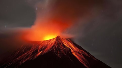
Volcanoes, tsunamis and meteorites

Volcanism is a set of processes and phenomena associated with the movement of magma in the upper mantle, the earth's crust and on the surface of the earth. As a result of volcanic eruptions, volcanic mountains, volcanic lava plateaus and plains, crater and dammed lakes, mud flows, volcanic tuffs, slags, breccias, bombs, ash, volcanic dust and gases are emitted into the atmosphere.
Volcanoes are located in seismically active belts, especially in the Pacific. In Indonesia, Japan, and Central America, there are several dozen active volcanoes - in total, on land there are from 450 to 600 active and about 1000 “dormant” volcanoes. About 7% of the world's population is dangerously close to active volcanoes. There are at least several dozen large underwater volcanoes at mid-ocean ridges.
In Russia, Kamchatka, Kurile Islands, Sakhalin. There are extinct volcanoes in the Caucasus and Transcaucasia.

The most active volcanoes erupt on average once every few years, all currently active - on average once every 10-15 years. In the activity of each volcano, there are apparently periods of relative decrease and increase in activity, measured in thousands of years.
Tsunamis often occur during eruptions of island and underwater volcanoes. Tsunami is a Japanese term for an unusually large sea wave. These are the waves high altitude and destructive forces arising in zones of earthquakes and volcanic activity of the ocean floor. The speed of movement of such a wave can vary from 50 to 1000 km/h, the height in the area of occurrence is from 0.1 to 5 m, and near the coast - from 10 to 50 m or more. Tsunamis often cause destruction on the coast - in some cases catastrophic: they lead to coastal erosion and the formation of turbidity currents. Another cause of ocean tsunamis are underwater landslides and avalanches that break into the sea.

.jpg)

In the last 50 years, about 70 seismogenic tsunamis of dangerous sizes have been recorded, of which 4% in the Mediterranean Sea, 8% in the Atlantic, and the rest in the Pacific Ocean. The most tsunami-hazardous shores are Japan, the Hawaiian and Aleutian Islands, Kamchatka, the Kuril Islands, Alaska, Canada, the Solomon Islands, the Philippines, Indonesia, Chile, Peru, New Zealand, the Aegean, Adriatic and Ionian Seas. In the Hawaiian Islands, tsunamis with an intensity of 3-4 points occur on average once every 4 years, on the Pacific coast South America- once every 10 years.
A flood is a significant inundation of an area as a result of rising water levels in a river, lake or sea. Floods are caused by heavy rainfall, melting snow, ice, hurricanes and storms, which contribute to the destruction of embankments, dams, and dams. Floods can be river (floodplain), surge (on sea coasts), planar (flooding of vast catchment areas), etc.

Large catastrophic floods are accompanied by a rapid and high rise in water levels, a sharp increase in the speed of flows, and their destructive power. Destructive floods occur almost every year in various regions of the earth. In Russia they are most common in the south of the Far East.

flood in the Far East in 2013
Disasters of cosmic origin are of no small importance. The Earth is constantly bombarded by cosmic bodies with sizes ranging from fractions of a millimeter to several meters. The larger the body, the less often it falls on the planet. Bodies with a diameter greater than 10 m, as a rule, invade the Earth's atmosphere, interacting only weakly with the latter. The bulk of the matter reaches the planet. The speed of cosmic bodies is enormous: approximately from 10 to 70 km/s. Their collision with the planet leads to strong earthquakes and an explosion of the body. Moreover, the mass of the destroyed substance of the planet is hundreds of times greater than the mass of the fallen body. Huge masses of dust rise into the atmosphere, shielding the planet from solar radiation. The earth is cooling. The so-called “asteroid” or “comet” winter is coming.
According to one hypothesis, one of these bodies, which fell in the Caribbean hundreds of millions of years ago, led to significant physical and geographical changes in the area, the formation of new islands and reservoirs, and along the way to the extinction of most of the animals that inhabited the Earth, in particular dinosaurs .

Some cosmic bodies could have fallen into the sea in historical times (5-10 thousand years ago). According to one version, the global flood, described in the legends of different nations, could have been caused by a tsunami as a result of a cosmic body falling into the sea (ocean). The body could have fallen into the Mediterranean or the Black Sea. Their coasts were traditionally inhabited by peoples.
Fortunately for us, collisions between the Earth and large cosmic bodies occur very rarely.
NATURAL DISASTER IN THE HISTORY OF THE EARTH
Natural disasters of antiquity
According to one hypothesis, natural disasters could cause physical and geographical changes in the hypothetical supercontinent Gondwana, which existed approximately 200 million years ago in the southern hemisphere of the Earth.

The southern continents have general history development natural conditions- they were all part of Gondwana. Scientists believe that the internal forces of the Earth (the movement of mantle matter) led to the split and expansion of a single continent. There is also a hypothesis about the cosmic reasons for the change in the appearance of our planet. It is believed that the collision of an extraterrestrial body with our planet could have caused the splitting of a giant landmass. One way or another, in the spaces between the individual parts of Gondwana, the Indian and Atlantic oceans gradually formed, and the continents took their modern position.
When trying to “put together” the fragments of Gondwana, one can come to the conclusion that some land areas are clearly missing. This suggests that there could be other continents that disappeared as a result of some natural disasters. Disputes about the possible existence of Atlantis, Lemuria and other mysterious lands still continue.

For a long time it was believed that Atlantis was a huge island (or continent?) that sank in the Atlantic Ocean. Currently, the bottom of the Atlantic Ocean has been well examined and it has been established that there is no island there that sank 10-20 thousand years ago. Does this mean that Atlantis did not exist? It's quite possible not. They began to look for her in the Mediterranean and Aegean seas. Most likely, Atlantis was located in the Aegean Sea and was part of the Santorian archipelago.

Atlantis
The death of Atlantis was first described in the works of Plato; myths about its death come to us from the ancient Greeks (the Greeks themselves could not describe this due to the lack of writing). Historical information suggests that the natural disaster that destroyed the island of Atlantis was the explosion of the Santorian volcano in the 15th century. BC e.
Everything that is known about the structure and geological history of the Santorian archipelago is very reminiscent of the legends of Plato. As geological and geophysical studies have shown, at least 28 km3 of pumice and ash were thrown out as a result of the Santorian explosion. The ejection products covered the surrounding area, the thickness of their layer reached 30-60 m. The ash spread not only within the Aegean Sea, but also in the eastern part of the Mediterranean Sea. The eruption lasted from several months to two years. During the last phase of the eruption, the interior of the volcano collapsed and sank hundreds of meters under the waters of the Aegean Sea.

Another type of natural disaster that changed the appearance of the Earth in ancient times is an earthquake. As a rule, earthquakes cause enormous damage and lead to casualties, but do not change the physical and geographical position of the regions. Such changes are caused by the so-called. super earthquakes. Apparently, one of these super-earthquakes occurred in prehistoric times. A crack up to 10,000 km long and up to 1,000 km wide was discovered at the bottom of the Atlantic Ocean. This crack could have formed as a result of a super earthquake. With a focal depth of about 300 km, its energy reached 1.5·1021 J. And this is 100 times more than the energy of the strongest earthquake. This should have led to significant changes in the physical and geographical position of the surrounding areas.
Another equally dangerous element is floods.
One of the global floods could be the biblical one already mentioned above global flood. As a result of it highest mountain Eurasia Ararat was under water, and some expeditions there are still looking for the remains of Noah's Ark.

global flood

Noah's Ark
Throughout the Phanerozoic (560 million years), eustatic fluctuations did not stop, and in certain periods the water level of the World Ocean increased by 300-350 m relative to its current position. At the same time, significant areas of land (up to 60% of the continents' area) were flooded.
In ancient times, cosmic bodies also changed the appearance of the Earth. The fact that in prehistoric times asteroids fell into the ocean is evidenced by craters on the bottom of the World Ocean:
Mjolnir crater in the Barents Sea. Its diameter was about 40 km. It arose as a result of the fall of an asteroid with a diameter of 1-3 km into a sea 300-500 m deep. This happened 142 million years ago. An asteroid at a distance of 1 thousand km caused a tsunami with a height of 100-200 m;
Lokne crater in Sweden. Formed about 450 million years ago by the fall of an asteroid with a diameter of about 600 m into a sea 0.5-1 km deep. The cosmic body caused a wave 40-50 m high at a distance of about 1 thousand km;
Eltanin crater. Located at a depth of 4-5 km. It arose as a result of the fall of an asteroid with a diameter of 0.5-2 km 2.2 million years ago, which led to the formation of a tsunami with a height of about 200 m at a distance of 1 thousand km from the epicenter.
Naturally, the height of the tsunami waves near the coast was significantly greater.
In total, about 20 craters have been discovered in the world's oceans.
Natural disasters of our time
Now there is no longer any doubt that the past century was marked by a rapid increase in the number of natural disasters and the volume of associated material losses and physical and geographical changes in territories. In less than half a century the number natural disasters tripled. The increase in the number of disasters occurs mainly due to atmospheric and hydrosphere hazards, which include floods, hurricanes, tornadoes, storms, etc. The average number of tsunamis remains virtually unchanged - about 30 per year. Apparently, these events are associated with a number of objective reasons: population growth, increased energy production and release, changes environment, weather and climate. It has been proven that air temperatures have increased by about 0.5 degrees Celsius over the past few decades. This led to an increase in the internal energy of the atmosphere by approximately 2.6·1021 J, which is tens and hundreds of times higher than the energy of the most powerful cyclones, hurricanes, volcanic eruptions and thousands and hundreds of thousands of times the energy of earthquakes and their consequences - tsunamis. It is possible that an increase in the internal energy of the atmosphere will destabilize the metastable ocean-land-atmosphere (OSA) system, which is responsible for the weather and climate on the planet. If this is so, then it is quite possible that many natural disasters are interconnected.

The idea that the increase in natural anomalies is generated by a complex anthropogenic impact on the biosphere, was put forward in the first half of the twentieth century by the Russian researcher Vladimir Vernadsky. He believed that the physical and geographical conditions on Earth are generally unchanged and are due to the functioning of living things. However, human economic activity disrupts the balance of the biosphere. As a result of deforestation, plowing of territories, drainage of swamps, urbanization, the surface of the Earth, its reflectivity changes, and the natural environment is polluted. This leads to changes in the trajectories of heat and moisture transfer in the biosphere and, ultimately, to the appearance of undesirable natural anomalies. Such complex degradation of the natural environment is the cause of natural disasters leading to global geophysical changes.

The historical genesis of earthly civilization is organically woven into the global context of the evolution of nature, which has a cyclical nature. It has been established that the geographical, historical and social phenomena taking place on the planet do not occur sporadically and arbitrarily, they are in organic unity with certain physical phenomena the surrounding world.
From a metaphysical point of view, the nature and content of the evolution of all life on Earth is determined by the regular change of historical and metric cycles of sunspot activity of the Sun. At the same time, the change of the cycle is accompanied by all kinds of cataclysms - geophysical, biological, social and others.
Thus, the metaphysical measurement of the fundamental qualities of space and time makes it possible to track and identify the most serious threats and dangers to the existence of earthly civilization in various periods of the development of world history. Based on the fact that safe paths for the evolution of earthly civilization are organically connected with the stability of the planet’s biosphere as a whole and the mutual dependence of the existence of all biological species in it, it is important not only to understand the nature of natural and climatic anomalies and cataclysms, but also to see ways of salvation and survival of humanity .
According to existing forecasts, in the foreseeable future there will be another change in the global historical-metric cycle. As a result, humanity will face dramatic geophysical changes on planet Earth. According to experts, natural and climatic disasters will lead to changes in the geographical configuration of individual countries, changes in the state of the habitat and ethnic feeding landscapes. Flooding of vast territories, an increase in the area of marine waters, soil erosion, and an increase in the number of lifeless spaces (deserts, etc.) will become common phenomena. Changes in environmental conditions, in particular the length of daylight hours, precipitation characteristics, the state of the ethno-feeding landscape, etc., will actively influence the characteristics of biochemical metabolism, the formation of the subconscious and mentality of people.
An analysis of the probable physical and geographical causes of powerful floods in Europe in recent years (in Germany, as well as in Switzerland, Austria and Romania) carried out by a number of scientists shows that the root cause of destructive cataclysms is, most likely, the release of ice from the Arctic Ocean.

In other words, due to the ongoing sharp climate warming, it is quite possible that the floods are just beginning. The amount of open blue water in the straits between the Arctic islands of the Great Canadian Archipelago has increased. Giant polynyas appeared even between the northernmost of them - Ellesmere Island and Greenland.
Liberation from multi-year, heavy fast ice, which previously literally clogged the above-mentioned straits between these islands, can lead to a sharp increase in the so-called Western flow of cold Arctic water into the Atlantic (with a temperature of minus 1.8 degrees Celsius) from the western side of Greenland. And this, in turn, will sharply reduce the cooling of this water, which is still flowing en masse from the eastern side of Greenland, going towards the Gulf Stream. In the future, the Gulf Stream may be cooled by this runoff by 8 degrees Celsius. At the same time, American scientists predicted a disaster if the water temperature in the Arctic rises by even one degree Celsius. Well, if it rises by a few degrees, then the ice covering the ocean will melt not in 70-80 years, as American scientists predict, but in less than ten.

According to experts, in the foreseeable future, coastal countries whose territories are directly adjacent to the waters of the Pacific, Atlantic and Arctic oceans will find themselves in a vulnerable position. Members of the Intergovernmental Panel on Climate Change believe that due to the active melting of glaciers in Antarctica and Greenland, sea levels could rise by 60 cm, which would lead to flooding of some island states and coastal cities. We are talking, first of all, about the territories of North and Latin America, Western Europe, South-East Asia.
This kind of assessment is contained not only in open scientific articles, but also closed research by special government agencies in the USA and Great Britain. In particular, according to Pentagon estimates, if in the next 20 years problems arise with the temperature regime of the Gulf Stream in the Atlantic, this will inevitably change the physical and geographical position of the continents, a global crisis in the world economy will occur, which will lead to new wars and conflicts in the world.
According to studies, the continent of Eurasia, the post-Soviet space and, above all, the modern territory of the Russian Federation will continue to retain the greatest resistance to natural disasters and anomalies on the planet, thanks to its physical and geographical data.

We are talking here about what is happening, according to scientists, is the movement of the energy center of the Sun to a “large physical-geographical zone” from the Carpathians to the Urals. Geographically, it coincides with the lands " historical Russia", which usually includes the modern territories of Belarus and Ukraine, the European part of Russia. The action of this kind of phenomena of cosmic origin means a point concentration of solar and other energy on the fauna and flora of a “large physical-geographical zone.” In a metaphysical context, a situation arises in which the settlement area of the peoples of this territory will belong to vital role in world social processes.

not so long ago there was a sea here
At the same time, according to existing geological estimates, the physical and geographical position of Russia, unlike many other countries, will suffer less from the catastrophic consequences of natural changes on Earth. It is expected that general climate warming will contribute to the regeneration of the natural climatic habitat and an increase in the diversity of fauna and flora in certain territories of Russia. Global changes will have a beneficial effect on the fertility of the lands of the Urals and Siberia. At the same time, experts suggest that the territory of Russia is unlikely to avoid large and small floods, the growth of steppe zones and semi-deserts.
CONCLUSION
Throughout the history of the Earth, the physical and geographical position of all land elements has changed under the influence of natural disasters.
Changes in factors of physical and geographical location can occur, as a rule, only under the influence of natural disasters.
The largest geophysical disasters associated with numerous casualties and destruction, changes in the physical and geographical data of territories, are caused as a result of seismic activity of the lithosphere, which most often manifests itself in the form of earthquakes. Earthquakes provoke other natural disasters: volcanic activity, tsunamis, floods. Real megatsunamis occurred when cosmic bodies with sizes ranging from tens of meters to tens of kilometers fell into the ocean or sea. Such events have happened many times in the history of the Earth.

Many experts of our time recognize the obvious trend towards an increase in the number of natural anomalies and disasters; the number of natural disasters per unit of time continues to grow. Perhaps this is due to the deterioration of the environmental situation on the planet, with an increase in gas temperature in the atmosphere.
According to experts, due to the melting of Arctic glaciers, new severe floods await the northern continents in the very near future.
Proof of the reliability of geological forecasts are various types of natural disasters that have occurred recently. Today natural anomalous phenomena, temporary climatic imbalances, sharp temperature fluctuations become constant companions of our lives. They are increasingly destabilizing the situation and making significant adjustments to the daily life of states and peoples of the world.
The situation is complicated by the increasing influence of the anthropogenic factor on the state of the environment.
In general, the upcoming natural, climatic and geophysical changes, which pose a serious threat to the very existence of the peoples of the world, require states and governments today to be prepared to act in crisis conditions. The world is gradually beginning to realize that the problems of the current vulnerability ecological system The Earth and the Sun have acquired the rank of global threats and require immediate resolution. According to scientists, humanity is still capable of coping with the consequences of natural and climate change.
The problem of global warming increasingly reminds us of itself. This is already affecting the lives of earthlings, because in the middle latitudes with a temperate climate in recent years the air temperature has been summer months began to regularly exceed 40 degrees Celsius, while the African heat is replaced by hurricanes and heavy rainfall. Such natural disasters cause a lot of inconvenience and damage, however, climate scientists predict that in the coming years climate shocks will become commonplace.
In particular, as reported by the portal Svopi.ru, climatologists from all over the world are calling for attention to global changes in the Earth’s climate that are already taking place today, because, according to scientists, climate turbulence will fully make itself felt by 2020 with a series of natural cataclysms that could turn into a global catastrophe.
Experts predict that within four years the world's population will feel the serious consequences of these changes. It is assumed that hurricanes and minor earthquakes will be the least of the troubles awaiting the Earth, however, researchers draw attention to the fact that climate changes, which were predicted for a long time, are not occurring as evenly and gradually as experts previously predicted. According to climatologists, these processes will manifest themselves unexpectedly, and where they are least expected. At the moment, there is a strong opinion in the scientific community that for the first time climate turbulence will manifest itself most acutely in the UK, since British Isles are in the zone of passage of cyclones from the subtropics and northern air currents simultaneously.
Let us recall that one of the consequences of the currently observed global warming is also the catastrophic melting of the Arctic ice and continental ice caps. They play a large role in climate balance by reflecting large amounts of sunlight, which prevents the Earth from overheating. At the same time, the dynamics of growth in average monthly and average annual temperatures, which continue to break new records with each recording period, also contributes to the stability of glaciers that have been untouched for tens of thousands of years in various parts of the planet. Humanity has already forgotten about the snows of Kilimanjaro; scientists predict the complete melting of Arctic ice in the coming years. At the same time, a serious threat looms over the Greenland ice sheet, the melting of which could raise the level of the world's oceans by many meters.
As climatologists from the UK, Holland and Germany note, between 2011 and 2014, as a result of observations, a record loss of ice cover was recorded in Greenland. The study was published in the journal Geophysical Research Letters. The researchers found that during this period, the planet's largest island lost a total of about a trillion tons of ice, which is equivalent to a contribution to global sea level rise of 0.75 millimeters per year. At the same time, it was found that the most intense ice melting occurred in 2012, when summer temperatures reached record highs.
This was established through observations using the CryoSat satellite, which has a radio altimeter. The vehicle's assessment of Greenland's ice loss was, as ESA notes, the highest accuracy available and is close to data from NASA's GRACE (Gravity Recovery And Climate Experiment) satellites.
According to the United Nations Information Center, by 2030, 250 thousand people will die annually from the effects of global climate change, and these data are in addition to previously announced forecasts. The main causes of increased mortality will be infectious diseases: malaria, diarrhea, malnutrition and heat stroke. The expected further warming and the associated increase in humidity will lead to the spread of various insects that carry diseases, and crops will suffer due to droughts, rainfall and extreme heat - all more people will starve.
As air pollution increases, the flowering period of plants will be prolonged, resulting in an increase in the number of people suffering from asthma and pollen allergies. As a result of water pollution, flooding and warming, diseases caused by dirty water will spread.
In just 60 years, more than 3,000 New Yorkers will die each year from extreme heat linked to climate change, US scientists warn. According to official data alone, more Americans die from extreme heat than from all other natural disasters combined. According to American climatologists, over the next 60 years the situation will only get worse. This is stated in a new study published in the specialized journal Environmental Health Perspectives. The New York City Panel on Climate Change projects that by 2080, the metropolitan area's average annual temperature will rise by 5.3 to 8.8 degrees Fahrenheit (2.9 to 4 .9 degrees Celsius). According to the National Climate Assessment 2014, the number of hot days before this time will triple.
You can often hear in the news that a natural disaster has occurred somewhere. This means that a strong storm or hurricane swept through, an earthquake occurred, or a stormy mud flow descended from the mountains. Tsunamis, floods, tornadoes, volcanic eruptions, landslides, drought - all these natural phenomena are destructive, claim lives, raze houses, neighborhoods, and sometimes entire cities, and cause serious economic damage.
Definition of cataclysm
What does the word "cataclysm" mean? This, by definition explanatory dictionary Ushakov, a sharp change in the conditions of organic life, which is observed on a large surface of the Earth (planet) and is caused by the influence of atmospheric, volcanic and geological processes.
The explanatory dictionary edited by Efremov and Shvedov defines a cataclysm as a destructive change in nature, a catastrophe.
Also, every dictionary indicates that in a figurative meaning, a cataclysm is a global and destructive change in the life of society, a disastrous social revolution.
Of course, you can see common features in all definitions. As we can see, the main meaning that the concept of “cataclysm” carries is destruction, disaster.
Types of natural and social disasters

Depending on the source of occurrence, the following types of disasters are distinguished:
- geological - earthquake or volcanic eruption, mudflow, landslide, avalanche or collapse;
- hydrological - tsunami, flood, gas (CO 2) breakthrough to the surface from the depths of a reservoir;
- thermal - forest or peat fire;
- meteorological - hurricane, storm, tornado, cyclone, blizzard, drought, hail, prolonged downpour.
These natural disasters differ in nature and duration (from several minutes to several months), but they all pose a threat to human life and health.
A separate category includes man-made disasters - accidents at nuclear installations, chemical facilities, wastewater treatment plants, dam breaks and other disasters. Their occurrence is provoked by a symbiosis of natural forces and the anthropogenic factor.
The most famous social cataclysm is war, revolution. Also, social emergencies can be associated with overpopulation, migration, epidemic, global unemployment, terrorism, genocide, separatism.
The most terrible cataclysms in the history of the Earth

In 1138, a powerful earthquake occurred in the city of Aleppo (modern Syria), which completely wiped out the city and claimed 230 thousand human lives.
In December 2004, an undersea earthquake with a magnitude of 9.3 occurred in the Indian Ocean. It triggered a tsunami. Huge 15-meter waves reached the shores of Thailand, India and Indonesia. The number of victims reached 300 thousand people.
In August 1931, a severe flood occurred in China due to monsoon rains, which claimed the lives of 4 million (!) people. And in August 1975, due to a powerful typhoon in China, the Banqiao Dam was destroyed. This provoked the largest flood in the last 2000 years, the water went 50 kilometers deep into the continent, creating artificial reservoirs with a total area of 12 thousand km 2. As a result, the death toll reached 200 thousand people.
What may await the blue planet in the future?
Scientists predict that in the future our planet will face severe disasters and cataclysms.
Global warming, which has been worrying progressive minds for more than 50 years, may in the future provoke unprecedented floods, droughts, and heavy torrential rains, which will lead not only to millions of victims, but also to a global economic and social crisis.
Also, do not forget that asteroid 99942, weighing 46 million tons and with a diameter of 500 meters, is inexorably approaching our planet. Astronomers predict a likely collision in 2029 that will destroy the Earth. NASA has created a special working group to solve this very serious
This year, the word “abnormal” is heard in almost every weather forecast: some regions are suffocating in fires due to abnormal heat, others are choking from rain, and rivers threaten to overflow their banks even in the Moscow region. What's happening on the planet? Scientists are putting forward new explanations for the increasing frequency of cataclysms and unanimously declare: it will get worse. But why?!
Chronicle: what do I care about snow, what do I like about heat...
The climate began to present us with surprises at the beginning of March. After a relatively calm winter, an early spring unexpectedly arrived - in fact, three weeks faster than the calendar.
March turned out to be unusually warm and sunny throughout almost the entire European territory of the country. However, then winter unexpectedly returned - with snow, ice and the whole arsenal of climate disasters. March gave way to a cool April, and then an unusually cold and rainy May. According to the Hydrometeorological Center, record cold and frosts were observed throughout the entire area from Barents Sea to Cherny and from the western border to the Urals until June, and the average monthly temperature in Central Russia turned out to be 2 degrees below normal.
At that time, the “May blizzard” hit Kaliningrad; in Syktyvkar, Kostroma and Pskov regions, people posted on the Internet photos of almost New Year’s landscapes: green grass, sticky leaves on trees, barely blooming flowers - and all this under the snow. IN Leningrad region the temperature dropped to -8 °C at night. In Moscow, May turned out to be the frostiest in the 21st century, and Victory Day was the most “oaky” in the entire history of the holiday. At the same time, beyond the Urals, the whole spring, on the contrary, turned out to be warmer than before.
June snowfall in Murmansk. Photo: www.globallookpress.com / instagram.com/narodnoe_tv/
But, alas, all this was just a prologue to the rampant elements. On May 29, a powerful hurricane hit Moscow with gusts of up to 30 m per second, which has never happened in the entire history of meteorological observations. This storm was the deadliest in Belokamennaya since the tornado of 1904: 18 people were killed and more than 170 were injured. Consequences of the hurricane in Moscow
At the end of May - beginning of June, destructive tornadoes and tornadoes swept through Tatarstan, Altai, the Urals - in Sverdlovsk and Chelyabinsk regions, in Bashkiria (in Tatarstan - with freezing rain). Summer snow fell in Moscow and St. Petersburg on June 2. Several regions located thousands of kilometers apart from each other were immediately hit by the elements: in Siberia, the Volga region and the North Caucasus. Hurricanes and prolonged downpours were observed in Barnaul, Togliatti, Kurgan region, North Ossetia, Kabardino-Balkaria, etc. Heavy rains and flooding in the Stavropol region have become the worst in the last half century. In the capital, June 15 turned out to be the coldest of this century - only +9.4 °C. Four months - March, April, May and June - were marked in the capital by exceeding monthly precipitation norms by more than 160-180%. But this record was broken on June 30, when 85% of the monthly norm fell in Moscow. This has not happened for 95 years - since 1923. Meanwhile, a “real northern summer” came to Murmansk and Severomorsk - on June 21, the temperature dropped sharply to 0 ° C, snowdrifts grew on the streets.


Residents of central Russia can envy those who live in Southern Siberia: in Krasnoyarsk, Abakan, Irkutsk, Novosibirsk, heat records set in May were continued in mid-June. It reached +34...+37 °C. And recently in the steppe regions of Crimea the temperature reached +42...+43 °C in the shade. There has been terrible heat for a month now in a number of European countries, even worse in Central Asia- in Tashkent, for example, during the day it reaches +49 °C.
In July, the number of weather anomalies and climate disasters did not decrease. In the first three days of July, half of the monthly rainfall fell in Moscow - 47 mm. The Russian Ministry of Emergency Situations has already warned that new natural disasters should be expected again in the near future. And scientists came up with new terms: “the weather is feverish”, “the climate is in hysterics.”
Version No. 1: It’s getting colder due to warming
There are many hypotheses that try to explain the cause of abnormal climate events. Among them there are both scientific ones and those that are born in conversations on a bench at the entrance. But they are no less interesting.
According to meteorologists, global warming is to blame. Because of it, the climate has become unstable and unbalanced. But why does warming lead to cooling?
Global warming is occurring faster at the poles than in mid-latitudes and even more so at the equator. Because of this, the temperature difference between the equator and the poles is becoming smaller. And the mechanism of atmospheric circulation is designed in such a way that the greater this temperature difference, the more intense the air masses move from west to east. It is this kind of west-east transfer that the residents of Russia are accustomed to. Cyclones coming to us from Europe then move towards the Ural Mountains.
“Due to a decrease in the temperature difference between the poles and the equator, this transfer, which is familiar to us, has slowed down, but transfers along the meridians have begun to be observed more and more often - air masses move from the north, then from the south,” explains Director of the Hydrometeorological Center of Russia Roman Vilfand. - It is the repeatability of meridional processes that leads to more intense cold snaps. In general, extreme events occur more often, with very low and very high temperatures observed. Paradox: during the period of warming, the intensity of cold snaps becomes greater than it was before global climate change. Our wonderful scientist, Academician Alexander Obukhov, said: “During the period of climate warming, the weather becomes nervous.” That is, there is less uniform weather. Such processes occur throughout the planet, but they are most noticeable in temperate latitudes.”
So, frequent invasions of cold Arctic air into the territory of Central Russia are caused by the fact that the Arctic itself is becoming warmer. And global warming also leads to the fact that some air masses are blocked by others for a long time. When in 2010, residents of the European part of Russia were suffocating for weeks from the smoke of peat fires, the drought and heat were caused precisely by a blocking anticyclone. But this can also happen with cold air masses, which apparently happened in May of this year.
“In addition, in May-June there was increased cyclonic activity in the North Atlantic,” says Head of the Climatology Laboratory of the Institute of Geography of the Russian Academy of Sciences Vladimir Semyonov. - Such an anomaly could be associated with strong changes ocean temperature."
Roman Vilfand warns: similar weather anomalies in our country are possible in the next 10 years.
Version No. 2: Scientists spoil the weather
When Europe sweltered in 2010, many were quick to blame the cataclysm on physicists conducting research at the Large Hadron Collider. This is the world's largest accelerator elementary particles located on the border of France and Switzerland. Suspicions that “scientists are spoiling our weather” are still heard, although the LHC has been shut down for repairs since the end of 2016.
Another scientific complex suspected of influencing the climate is located in Alaska. This is the American HAARP - a project to study the ionosphere and auroras. There have been rumors that it is capable of manipulating weather on a planetary scale since its launch in 1997. Conspiracy theorists blame HAARP for earthquakes, droughts, hurricanes and floods. By the way, similar installations exist in Norway, Russia (in the Nizhny Novgorod region), and Ukraine.
The weather anomalies were also associated with the launch of the Chinese Mo Tzu satellite, which was supposed to conduct an experiment on quantum teleportation. After the first successful sessions on the satellite, equipment malfunctions began. According to experts, they caused a sharp increase in the level of negative air ions, which could affect the climate.
Version No. 3: The sun goes out
Astronomers are alarmed: they have discovered a noticeable decrease in solar activity. Last years The level of magnetic activity of our star has decreased to record levels, which indicates fundamental changes in its depths, as well as the disastrous consequences of these processes for humanity. Scientists from Birmingham (UK) came to these conclusions.
Until recently, our star was in a state of great maximum, that is, increased activity. But in 2008 a new cycle began, which turned out to be surprisingly weak. Astronomers fear that the Sun has begun to fade.
One of the signs of the activity of a star is the presence of spots on its surface. And this year there are catastrophically few of them! The number of sunspots is gradually decreasing. The images show that the thickness of the layer where they are born is decreasing. In addition, the rotation of the star in its circumpolar regions has slowed down.
According to scientists, a period of abnormal calm of the C-sun can lead to long-term cooling on our planet. It is also possible that the weather quirks currently observed are harbingers of a more menacing cataclysm.

Version No. 4: climate weapons
Climate weapons are prohibited by international conventions, but this does not mean that work on them is not underway. And in some classifiers, weapons that can be called climatic are officially present. When a hurricane hit Moscow on May 29, resulting in casualties and tearing off part of the roof from the Senate Palace in the Kremlin, the people began to grumble: surely the West had used a secret technology that influenced the weather in Russia.
“Technologies similar to climate weapons are used when the clouds clear up for the holiday. By the way, this method of influencing the weather was developed specifically for military purposes, says military scientist Andrei Shalygin. - And now there are many companies in the world that offer their services for “weather regulation.” That is, experiments are being carried out on the climate that no one controls! What does this mean? Yes, you can spray reagents around one city for a holiday, and this will change the weather there, but in another region, a thousand kilometers away, this will backfire. Methods of provocation natural phenomena diverse. For example, you can spray chemical components onto two cyclones moving towards each other. And these components will react when combined, and then a much more powerful hurricane will hit the area. This way you can provoke not only hurricanes, but also rainstorms, mudflows, floods, tornadoes, etc.”
They say that the Pentagon is paying increased attention to work in the field of climate change (the same HAARP complex in Alaska is under the control of the US military department). According to some reports, the Americans even planned to fight terrorists from ISIS (an organization banned in Russia. - Ed.), causing persistent hot winds in the territory of their residence, directed streams of hot wind with clouds of sand.
The advantages of climate weapons are obvious: how to prove that a particular natural disaster was caused artificially? And it can cause colossal damage - affecting yields and agricultural production, and therefore provoking an economic decline in the country and dissatisfaction with the authorities. Unravel political situation and kindling the fire of revolution is the job of political strategists.

The HAARP ionospheric research complex in Alaska is controlled by the US military department. Photo: Public Domain
Version No. 5: The Gulf Stream does not heat
AiF has written about this hypothesis before. Moreover, he gave a forecast that in the coming years it will begin to work and this will lead to cooling in Europe.
We are talking about stopping the warm ocean current Gulf Stream, which warms old light. And thanks to the North Atlantic Current, which is its continuation, Murmansk remains an ice-free port.
The mechanism for stopping the Gulf Stream looks like this. As it moves north, this powerful current meets the cold Labrador Current, which “dives” under it, pushing it towards Europe. This happens because the water in the Labrador Current is saltier and heavier. The picture looks like a two-level interchange - two powerful flows happily diverge.
Now let's see what happens as a result of global warming. Enormous masses of ice are melting in the Arctic - primarily the giant Greenland glacier. And ice, as you know, is frozen fresh (not salty!) water. Plus, the flow of Siberian rivers, which also carry fresh water into the ocean, is increasing. As a result, the salinity of water in the Arctic Ocean decreases. And since fresh water lighter than salty water, it stops sinking and stops the warm Gulf Stream. In addition, the Labrador Current, also diluted with fresh water, becomes less dense and no longer “dives” under the Gulf Stream, but simply crashes into it. The two-level interchange turns into a banal intersection.
By the way, Europe has experienced many ice ages in its history. The last of them, known as the Little Glacial, began in the 14th century. and, according to researchers, was caused precisely by the slowdown of the Gulf Stream.
Almost all ancient peoples believed that terrible cataclysms hit our planet, which destroyed all life on the planet. Nowadays, with the advent of the twenty-first century, natural disasters claim millions of lives every day. Could these be harbingers of a global catastrophe that is coming upon us with all its might and force?
Be that as it may, our nature has four elements, which rage more and more every year.

There are more than five hundred volcanoes throughout the earth. The largest belt of fire covers the coasts Pacific Ocean. It is worth noting that 328 of them have already erupted with terrible force in those days that our ancestors can remember.

Everyone knows from an early age that it is fires that can cause the economy of our country and the earth as a whole the greatest destruction and sad consequences. At the same time, it doesn’t matter at all in what area a fire breaks out, because it can take lives. According to the World Health Organization, every year thousands of people die, if not in the fires themselves, then from the acrid smoke that is released from fires in peat bogs. The acrid smoke that wafts along roads can also cause fatal car accidents.
Earth


Every year across the planet, tectonic plates shift. These vibrations and tremors can, in turn, turn out to be very strong earthquakes that can completely destroy any city in a matter of seconds. Every two weeks on the planet, one very strong earthquake occurs. And it’s good if it doesn’t affect people’s lives.

Despite man's intelligence, he simply cannot compete with the power and enormous force of nature. Every year all over the Earth, various landslides and avalanches occur. This terrible phenomenon can completely destroy everything that comes in its path. Even a concrete structure will not become an obstacle to him. But the worst thing is that all this force with the debris will be eliminated on people.


This is the worst nightmare of all people who live on the ocean coast. Earthquakes can provoke the formation of huge waves that will quickly destroy everything in their path. Their speed can reach fifteen thousand kilometers, and their destructive force is capable of destroying any structure.
Flood

The rapid flow of rising water can leave even the most Big city. This most often occurs after prolonged rains.

Every person loves warm Sun rays, which awaken the world from hibernation. But its excessive interaction with nature can completely destroy the crop, or cause severe drought, which will subsequently provoke fires.

Typhoon or hurricane

Air currents of the earth constantly meet each other. And in those frequent moments when a warm and a cold cyclone meet, a strong wind flow can form. Its speed can reach several thousand kilometers. He is capable of uprooting trees and carrying away houses. The air moves along a certain trajectory, which starts at the corners of the spiral and rapidly moves towards its center. It is at this point that the most terrible destruction and irreparable consequences occur.
Tornado or tornado

This is a kind of air funnel that literally pulls into itself everything that can be torn off the ground. His strength is so great that he is able to spin the largest objects around within himself. Cars and houses can get caught in it and literally break into pieces.

Due to constant changes in climate, the entire cycle may change. Thus, in countries where winter has never occurred, it may snow.